1900s (20th Century) Maps of Harvel, Illinois
Explore 7 historic maps of Harvel from the 1900s (20th Century). These maps offer a rare glimpse into what life looked like during the 1900s — showing old roads, neighborhoods, homes, and landmarks that have changed or disappeared over time.
Whether you're researching your family's past, planning a metal detecting trip, or studying how Harvel's landscape evolved across the 1900s, these high-resolution maps are a powerful tool for exploring the history of this region.
- Focus on a specific era: All maps on this page are from the 1900s, giving you a focused view of this time period.
- See what’s changed: Compare century-old streets, trails, and buildings to today's modern landscape using overlays and satellite layers.
- Research with precision: Use these maps for genealogy, historical research, land use analysis, or educational projects.
- View, download, or print: Maps are fully viewable online in high resolution, and can be downloaded or printed for your own records.
Start exploring Harvel's history through authentic maps from the 1900s. This is your window into the past.
Harvel, IL maps
(7)- 1923 Map of Raymond, 1965 Print
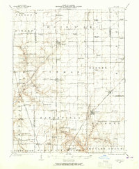 1923 Raymond1965 Print · USGSCentral Illinois at the start of the 1920s showcases a high-density rural network of railroads and country schoolhouses. Researchers can trace family history at sites like the Studebaker School, Bethel Church, and old settlements like Thomasville or Farmersville.2 unique versions available
 - 1925 Map of Raymond
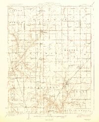 1925 Raymond1925 Print · USGSIn the mid-1920s, this Montgomery County landscape was a thriving rail-and-farm network centered on Raymond and Harvel. Genealogists can trace family roots through dozens of local landmarks like South Bois d'Arc School, Providence Church, and Honey Bend.2 unique versions available
 - 1958 Map of Decatur, 1971 Print
 1958 Decatur1971 Print · USGSCentral Illinois in the mid-twentieth century shows a landscape defined by industrial rail hubs and the creation of large reservoirs. Researchers can trace historic corridors like the Penn Central or locate landmarks such as Lincoln Log Cabin State Park and Lake Springfield.3 unique versions available
 - 1961 Map of Decatur
 1961 Decatur1961 Print · USGSCentral Illinois in the late fifties was a bustling corridor of rail lines and prairie commerce centered on the state capital. Genealogists and historians can trace the intricate connections between Springfield, Decatur, and dozens of smaller settlements like Nokomis and Arcola.2 unique versions available
 - 1979 Map of Raymond, 1980 Print
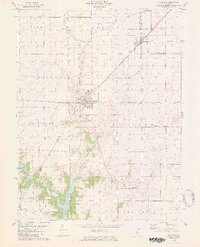 1979 Raymond1980 Print · USGSThe Montgomery County prairie is shown here during the late 1970s, as agricultural townships surround the northern waters of the local reservoir. Genealogists can locate family landmarks like Asbury Cem and Cass Cem or trace the Norfolk and Western rail corridor.2 unique versions available
 - 1982 Map of Litchfield
 1982 Litchfield1982 Print · USGSThe coal and rail corridors of Central Illinois are captured here in the early eighties as the region balanced industrial mining with its agricultural roots. Researchers can trace family history through sites like Zelmer Memorial Cemetery or the grounds of Blackburn College and the Crown Mine No 1.
 - 1998 Map of Raymond, 2002 Print
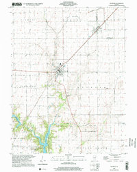 1998 Raymond2002 Print · USGSCentral Illinois farmland near the turn of the millennium is anchored by the rail towns of Raymond and Harvel. Researchers can trace rural cemetery locations like St Raymond Cem and explore the northern waters of Lou Yaeger Lake.
End of results
Showing maps 1-7 of 7
Top cities near Harvel
- Taylorville historical maps
- Litchfield historical maps
- Hillsboro historical maps
- Auburn historical maps
- Kincaid historical maps
- Divernon historical maps
See more
Frequently asked questions
- What are the different types of historical maps available for Harvel?
- What is the oldest map of Harvel?
- Where can I purchase historical maps of Harvel for my home or office?
- Where can I download high-res historical maps of Harvel?
- Are there historical topographic maps available for Harvel?
- Is there historical aerial imagery available for Harvel?
- Where are historical maps of Harvel sourced from?