1960s Maps of Henderson County, Illinois
Explore 8 historic maps of Henderson County from the 1960s. These maps offer a rare glimpse into what life looked like during the 1960s — showing old roads, neighborhoods, homes, and landmarks that have changed or disappeared over time.
Whether you're researching your family's past, planning a metal detecting trip, or studying how Henderson County's landscape evolved across the 1960s, these high-resolution maps are a powerful tool for exploring the history of this region.
- Focus on a specific era: All maps on this page are from the 1960s, giving you a focused view of this time period.
- See what’s changed: Compare century-old streets, trails, and buildings to today's modern landscape using overlays and satellite layers.
- Research with precision: Use these maps for genealogy, historical research, land use analysis, or educational projects.
- View, download, or print: Maps are fully viewable online in high resolution, and can be downloaded or printed for your own records.
Start exploring Henderson County's history through authentic maps from the 1960s. This is your window into the past.
Henderson County, IL maps
(8)- 1961 Map of Burlington
 1961 Burlington1961 Print · USGSThe tri-state borderlands along the Mississippi River are captured here during the late fifties and early sixties, showing the vital river-and-rail economy of Iowa, Illinois, and Missouri. Genealogists and historians can trace the development of major hubs like Galesburg and Macomb alongside landmark sites such as the Iowa Ordnance Plant and the historic river town of Nauvoo.
 - 1961 Map of Davenport
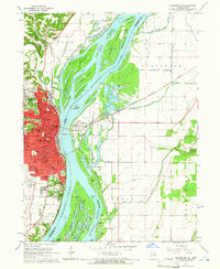
 1961 Davenport1961 Print · USGSThe Quad Cities and the eastern Iowa riverlands are captured here in the early sixties, showing the region's transition into a modern industrial and transit hub. Genealogists and historians can trace the paths of major railroads and find river landmarks like Rock Island Arsenal, Huron Island, and the Coralville Reservoir.
 - 1962 Map of Davenport
 1962 Davenport1962 Print · USGSThe Quad Cities and the Mississippi River corridor are shown at their industrial peak just before the interstate era fully transformed the region. Researchers can trace the sprawling rail networks of the Chicago Rock Island and Pacific and find landmarks like the Rock Island Arsenal and Wild Cat Den State Park.
 - 1963 Map of Burlington
 1963 Burlington1963 Print · USGSThe tri-state river country of the Mississippi and Illinois valleys comes alive in this mid-century survey. Genealogists and historians can trace the industrial and academic growth of the region, from the Iowa Ordnance Plant to campuses like Knox College and Western Illinois University.
 - 1964 Map of Burlington, 1965 Print
 1964 Burlington1965 Print · USGSMid-century Burlington and the Mississippi riverfront are captured here as the city expanded westward toward the Burlington Municipal Airport. Genealogists can locate family landmarks like Sacred Heart Cemetery, St Johns School, and the scattered homes of Heapsville.3 unique versions available
 - 1964 Map of Lomax, 1965 Print
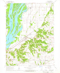 1964 Lomax1965 Print · USGSThe Mississippi River floodplain and rail junctions of Henderson County are captured here in the mid-1960s. Genealogists can trace family sites at Gittings Cem and Freeland Cem or follow the heavy rail traffic through Lomax and Iowa Junction.
 - 1964 Map of Dallas City, 1965 Print
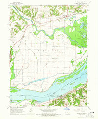 1964 Dallas City1965 Print · USGSThe Mississippi River floodplain in the 1960s reveals a landscape of industrial rail lines and intricate backwaters. Trace the historic tracks of the Atchison Topeka and Santa Fe or locate rural landmarks like Oak Grove Ch and Eureka Sch.4 unique versions available
 - 1964 Map of Kingston, 1966 Print
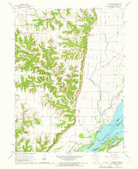 1964 Kingston1966 Print · USGSDes Moines County, Iowa, and the Mississippi River bottoms are captured here in the mid-1960s. Researchers can trace the river's path through Running Slough or locate local landmarks like Tama Sch and St Pauls Ch.2 unique versions available
End of results
Showing maps 1-8 of 8
Top cities of Henderson County
- Oquawka historical maps
- Stronghurst historical maps
- Lomax historical maps
- Carman historical maps
- Biggsville historical maps
- Rozetta historical maps
See more
Frequently asked questions
- What are the different types of historical maps available for Henderson County?
- What is the oldest map of Henderson County?
- Where can I purchase historical maps of Henderson County for my home or office?
- Where can I download high-res historical maps of Henderson County?
- Are there historical topographic maps available for Henderson County?
- Is there historical aerial imagery available for Henderson County?
- Where are historical maps of Henderson County sourced from?