1940s Maps of Henry County, Illinois
Explore 6 historic maps of Henry County from the 1940s. These maps offer a rare glimpse into what life looked like during the 1940s — showing old roads, neighborhoods, homes, and landmarks that have changed or disappeared over time.
Whether you're researching your family's past, planning a metal detecting trip, or studying how Henry County's landscape evolved across the 1940s, these high-resolution maps are a powerful tool for exploring the history of this region.
- Focus on a specific era: All maps on this page are from the 1940s, giving you a focused view of this time period.
- See what’s changed: Compare century-old streets, trails, and buildings to today's modern landscape using overlays and satellite layers.
- Research with precision: Use these maps for genealogy, historical research, land use analysis, or educational projects.
- View, download, or print: Maps are fully viewable online in high resolution, and can be downloaded or printed for your own records.
Start exploring Henry County's history through authentic maps from the 1940s. This is your window into the past.
Henry County, IL maps
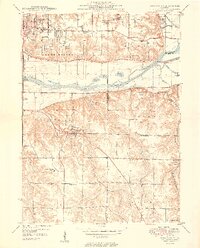
(6)- 1940 Map of Galva, 1957 Print
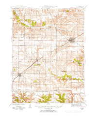 1940 Galva1957 Print · USGSHenry and Knox counties are captured here as a bustling railroad landscape in the early 1940s. Genealogists can trace the rural school and church networks of the era, from the uniquely named Swamp College Sch to the settlement at Bishop Hill.2 unique versions available
 - 1944 Map of Galva
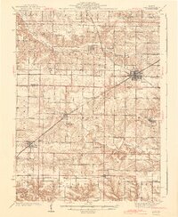 1944 Galva1944 Print · USGSNorthwestern Illinois farmland is captured in the 1940s as a thriving network of rail towns and country schools. Genealogists can locate family landmarks like Piatt Cem or trace the early layout of historic Bishop Hill and Galva.2 unique versions available
 - 1944 Map of Kewanee
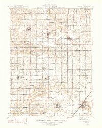
 1944 Kewanee1944 Print · USGSHenry and Stark Counties in the 1940s show a landscape of thriving rail towns and closely spaced country schoolhouses. Genealogists can locate family-named landmarks like Cavanagh Cem and Bumble Bee Sch along the Spoon River valley.3 unique versions available
 - 1947 Map of Woodhull
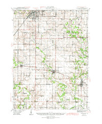
 1947 Woodhull1947 Print · USGSThe Illinois prairie at mid-century reveals a dense network of family farms and rural institutions near the Henry and Knox county lines. Genealogists can trace ancestral sites through dozens of named schools and cemeteries like Prairie Flower Sch and Oxford Cem.2 unique versions available
 - 1949 Map of Coal Valley
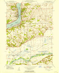
 1949 Coal Valley1949 Print · USGSThe Rock River valley was a hub of coal mining and transit in the late 1940s as the Moline area expanded eastward. Local researchers can trace family landmarks and industry at Black Hawk Mine, the Illinois and Mississippi Canal, and Kingdom Sch.2 unique versions available
 - 1949 Map of Port Byron, 1954 Print
 1949 Port Byron1954 Print · USGSThe confluence of the Mississippi and Rock Rivers defined the mid-century economy of these Illinois and Iowa river towns. Genealogists and local historians can trace rural school districts and family burial grounds including Leafy Bower Sch, Edwards Cem, and Zion Ch.2 unique versions available
End of results
Showing maps 1-6 of 6
Top cities of Henry County
- Kewanee historical maps
- Geneseo historical maps
- Colona historical maps
- Galva historical maps
- Cambridge historical maps
- Orion historical maps
See more
Frequently asked questions
- What are the different types of historical maps available for Henry County?
- What is the oldest map of Henry County?
- Where can I purchase historical maps of Henry County for my home or office?
- Where can I download high-res historical maps of Henry County?
- Are there historical topographic maps available for Henry County?
- Is there historical aerial imagery available for Henry County?
- Where are historical maps of Henry County sourced from?