1990s Maps of Henry County, Illinois
Explore 14 historic maps of Henry County from the 1990s. These maps offer a rare glimpse into what life looked like during the 1990s — showing old roads, neighborhoods, homes, and landmarks that have changed or disappeared over time.
Whether you're researching your family's past, planning a metal detecting trip, or studying how Henry County's landscape evolved across the 1990s, these high-resolution maps are a powerful tool for exploring the history of this region.
- Focus on a specific era: All maps on this page are from the 1990s, giving you a focused view of this time period.
- See what’s changed: Compare century-old streets, trails, and buildings to today's modern landscape using overlays and satellite layers.
- Research with precision: Use these maps for genealogy, historical research, land use analysis, or educational projects.
- View, download, or print: Maps are fully viewable online in high resolution, and can be downloaded or printed for your own records.
Start exploring Henry County's history through authentic maps from the 1990s. This is your window into the past.
Henry County, IL maps
(14)- 1991 Map of Coal Valley, 1992 Print
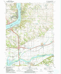
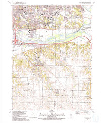 1991 Coal Valley1992 Print · USGSThe confluence of the Rock and Green Rivers defines the landscape of southeastern Rock Island County in the early 1990s. Genealogists and local historians can trace family-named sites like Bowlesburg Cem, Arrowhead Ranch, and Good Shepherd Sch.
 - 1991 Map of Cambridge, 1992 Print
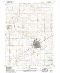
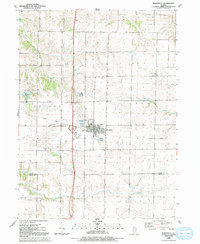
 1991 Cambridge1992 Print · USGSCambridge and its surrounding townships in the early 1990s show a settled landscape of family farms and civic centers. Genealogists can locate several historic burial sites like Munson Cem and Rose Dale Cem or trace the path of the Edwards River.
 - 1991 Map of Geneseo, 1992 Print
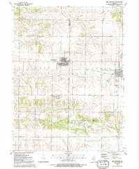
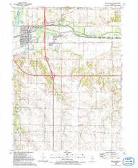
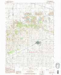
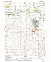 1991 Geneseo1992 Print · USGSGeneseo and the townships of Henry County are documented here as they appeared in the early nineties, centered on the intersection of river and rail history. Researchers can locate family landmarks like North Cem, Faith Ch, and the Hammond Henry Hospital.
 - 1991 Map of German Corner, 1992 Print
 1991 German Corner1992 Print · USGSHenry County farmland in the early nineties is defined by the winding Edwards River and traditional township boundaries. Researchers can trace local history through the State Road Ch and several burial sites like Liberty Cem and Mount Zion Cem.
 - 1991 Map of New Windsor, 1992 Print
 1991 New Windsor1992 Print · USGSWestern Illinois farm country and the villages of Mercer County are captured here just before the turn of the millennium. Researchers can trace the Old Railroad Grade between New Windsor and Alpha or locate ancestors at Calvary Cem and Oxford Cem.
 - 1991 Map of Galva, 1992 Print
 1991 Galva1992 Print · USGSThe communal settlement of Bishop Hill and the bustling rail-era city of Galva are documented here in the early 1990s. Trace local history through landmarks like the Museum, St Johns Cem, and the Old Railroad Grade crossing the prairie.
 - 1991 Map of Orion, 1992 Print
 1991 Orion1992 Print · USGSThe intersection of Rock Island, Henry, and Mercer counties comes to life in this early 1990s portrait of Illinois farm country. Local historians can trace the foundations of Orion and Sherrard or find family roots at Beulah Ch and Brush Hill Cem.
 - 1991 Map of Andover, 1992 Print
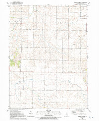
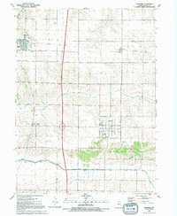 1991 Andover1992 Print · USGSHenry County's agricultural heartland is documented here in the early nineties, centered on the historic village of Andover. Researchers can trace the path of the Old Railroad Grade and locate local landmarks like the Township Cem and Love Park.
 - 1991 Map of Atkinson, 1992 Print
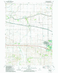 1991 Atkinson1992 Print · USGSThe village of Atkinson and the surrounding Illinois prairie are shown here in the early nineties as the region maintained its deep agricultural and water-management roots. Researchers can trace family history at St Anthony Cem, locate the Spring Creek Grange Hall, or follow the path of the Hennepin Canal.
 - 1991 Map of Port Byron, 1992 Print
 1991 Port Byron1992 Print · USGSThe riverfront communities of Port Byron and Le Claire are captured here in the early nineties as they expanded along the Mississippi. Genealogists and historians can trace numerous family landmarks like Yost Cem, Edwards Cem, and the Cody Sch.
 - 1992 Map of Woodhull
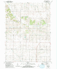
 1992 Woodhull1992 Print · USGSSurrounding the Henry and Knox county line in the early nineties, this area reveals a deep-rooted agricultural community. Genealogists can locate family names at Summit Level Cemetery or Woodhull Cemetery and trace the path of the Old Railroad Grade.
 - 1992 Map of Nekoma
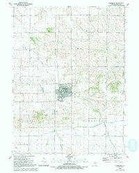
 1992 Nekoma1992 Print · USGSNekoma and the surrounding Henry County townships are shown here in the early 1990s as a landscape of steady agricultural tradition. Researchers can trace the path of the Old Railroad Grade or locate family sites at the Piatt Cem and the small settlement of Nekoma.
 - 1992 Map of Green Rock
 1992 Green Rock1992 Print · USGSHenry County is captured in the early 1990s as a landscape of historic waterways and quiet rural crossroads. Genealogists and local historians can trace family-named sites like Dayton Cem and Warner or follow the path of the Hennepin Canal.
 - 1994 Map of Neponset, 1998 Print
 1994 Neponset1998 Print · USGSThe village of Neponset and the rolling Bureau County prairie are shown here during the late twentieth century. Researchers can trace the Burlington Northern line and locate local landmarks like Francis Park and Floral Hill Cem.
End of results
Showing maps 1-14 of 14
Top cities of Henry County
- Kewanee historical maps
- Geneseo historical maps
- Colona historical maps
- Galva historical maps
- Cambridge historical maps
- Orion historical maps
See more
Frequently asked questions
- What are the different types of historical maps available for Henry County?
- What is the oldest map of Henry County?
- Where can I purchase historical maps of Henry County for my home or office?
- Where can I download high-res historical maps of Henry County?
- Are there historical topographic maps available for Henry County?
- Is there historical aerial imagery available for Henry County?
- Where are historical maps of Henry County sourced from?