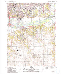
1991 Map of Coal Valley
USGS Topo · Published 1992About this map
The Rock River and Green River converge in this detailed mapping of the Quad Cities' southeastern reach, where industrial river corridors meet the rural uplands of Rock Island Co and Henry Co. The landscape transitions from the urban density of Moline and East Moline to the smaller settlements of Coal Valley and Carbon Cliff. Genealogical interest is found in numerous local landmarks, including Trinity Ch, Glenwood Cem, and Homestead Cem. The mapping shows the established residential growth of South Moline alongside remaining industrial features like the sandpit near Coal Creek. Strategic infrastructure, including Interstate 80 and the Burlington Northern railroad, underscores the area's role as a regional transportation hub in the late twentieth century.
Find a feature on this map
53 named features on this map. Tap any name to fly to it.
Don’t see what you’re looking for? This feature index may not catch every label — zoom into the map to look around manually.
Map Details
Editions of this 1991 Coal Valley Map
This is the sole edition of this map. No revisions or reprints were ever made.
Other maps of this area

1891 · Davenport
USGS Topo · 1:62,500

1892 · Leclaire
USGS Topo · 1:62,500

1893 · Leclaire
USGS Topo · 1:62,500

1894 · Davenport
USGS Topo · 1:62,500

1899 · Clinton
USGS Topo · 1:125,000

1901 · Rock Island
USGS Topo · 1:125,000

1910 · Rock Island
USGS Topo · 1:125,000

1912 · Milan
USGS Topo · 1:62,500

1937 · Orion
USGS Topo · 1:62,500

1944 · Milan
USGS Topo · 1:62,500