1980s Maps of Annawan, Illinois
Explore 3 historic maps of Annawan from the 1980s. These maps offer a rare glimpse into what life looked like during the 1980s — showing old roads, neighborhoods, homes, and landmarks that have changed or disappeared over time.
Whether you're researching your family's past, planning a metal detecting trip, or studying how Annawan's landscape evolved across the 1980s, these high-resolution maps are a powerful tool for exploring the history of this region.
- Focus on a specific era: All maps on this page are from the 1980s, giving you a focused view of this time period.
- See what’s changed: Compare century-old streets, trails, and buildings to today's modern landscape using overlays and satellite layers.
- Research with precision: Use these maps for genealogy, historical research, land use analysis, or educational projects.
- View, download, or print: Maps are fully viewable online in high resolution, and can be downloaded or printed for your own records.
Start exploring Annawan's history through authentic maps from the 1980s. This is your window into the past.
Annawan, IL maps
(3)- 1983 Map of Annawan, 1984 Print
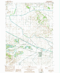 1983 Annawan1984 Print · USGSThe village of Annawan and the surrounding Henry County farmlands are shown in the early 1980s as the railroad and canal corridor still dominated the landscape. Genealogists and historians can trace family burial sites at Sacred Heart Cem or locate the historic Lock No 23 along the Hennepin Canal State Parkway.
 - 1983 Map of Mineral, 1984 Print
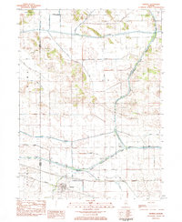 1983 Mineral1984 Print · USGSIn the early 1980s, the Illinois prairie around the Bureau and Henry county line was a landscape of rail-and-water commerce. Trace the path of the Iowa Railroad through Mineral or explore the historic infrastructure of Lock No 22 along the Hennepin Canal.
 - 1985 Map of Kewanee
 1985 Kewanee1985 Print · USGSNorth-central Illinois in the mid-eighties shows a landscape of river-valley industry and prairie transit. Researchers can trace family roots through Evergreen Memory Garden or follow the historic Hennepin Canal past Tiskilwa and Wyanet.2 unique versions available
End of results
Showing maps 1-3 of 3
Top cities near Annawan
- Kewanee historical maps
- Galva historical maps
- Osceola historical maps
- Atkinson historical maps
- Sheffield historical maps
- Bradford historical maps
See more
Frequently asked questions
- What are the different types of historical maps available for Annawan?
- What is the oldest map of Annawan?
- Where can I purchase historical maps of Annawan for my home or office?
- Where can I download high-res historical maps of Annawan?
- Are there historical topographic maps available for Annawan?
- Is there historical aerial imagery available for Annawan?
- Where are historical maps of Annawan sourced from?