Old Maps of Mount Carbon, Illinois for Genealogy
Trace your family roots with 12 historic maps of Mount Carbon. These high-res maps reveal old neighborhoods, homesites, landmarks, and streets — helping you uncover where your ancestors lived and how the area evolved over time.
- Explore historic neighborhoods: Identify where your relatives may have lived in the 1800s or 1900s.
- Compare maps over time: Trace the changes in streets, buildings, and landmarks for multi-generational research.
- Perfect for genealogy & ancestry research: Used by family historians and researchers to map out lineage and migration.
These maps are an incredible resource for exploring your personal connection to Mount Carbon's past.
Mount Carbon, IL maps
(12)- 1910 Map of Murphysboro
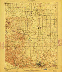 1910 Murphysboro1910 Print · USGSCovers Mount Carbon, including Carbondale, Murphysboro, and other nearby areas2 unique versions available
 - 1938 Map of Murphysboro, 1958 Print
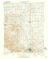 1938 Murphysboro1958 Print · USGSCovers Mount Carbon, including Carbondale, Murphysboro, and other nearby areas
 - 1949 Map of Paducah
 1949 Paducah1949 Print · USGSCovers Mount Carbon, including Cape Girardeau, Paducah, and other nearby areas2 unique versions available
 - 1950 Map of Paducah
 1950 Paducah1950 Print · USGSCovers Mount Carbon, including Cape Girardeau, Paducah, and other nearby areas
 - 1954 Map of Paducah
 1954 Paducah1954 Print · USGSCovers Mount Carbon, including Cape Girardeau, Paducah, and other nearby areas2 unique versions available
 - 1961 Map of Paducah
 1961 Paducah1961 Print · USGSCovers Mount Carbon, including Cape Girardeau, Paducah, and other nearby areas2 unique versions available
 - 1964 Map of Paducah
 1964 Paducah1964 Print · USGSCovers Mount Carbon, including Cape Girardeau, Paducah, and other nearby areas2 unique versions available
 - 1968 Map of Murphysboro, 1970 Print
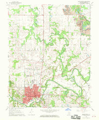 1968 Murphysboro1970 Print · USGSCovers Mount Carbon, including Carbondale, Murphysboro, and other nearby areas3 unique versions available
 - 1984 Map of Carbondale, 1985 Print
 1984 Carbondale1985 Print · USGSCovers Mount Carbon, including Carbondale, Marion, and other nearby areas
 - 1986 Map of Carbondale
 1986 Carbondale1986 Print · USGSCovers Mount Carbon, including Carbondale, Marion, and other nearby areas
 - 1987 Map of Paducah, 1988 Print
 1987 Paducah1988 Print · USGSCovers Mount Carbon, including Cape Girardeau, Paducah, and other nearby areas
 - 2024 Map of Murphysboro, 2024 Print
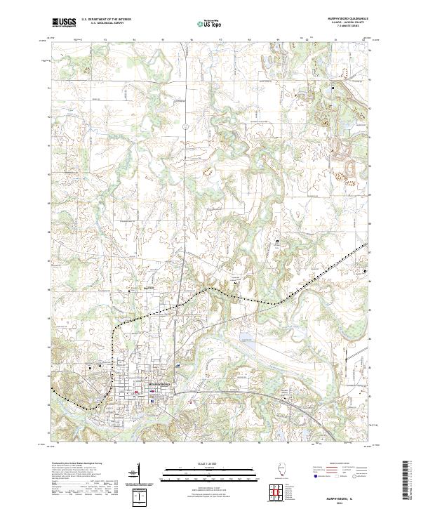 2024 Murphysboro2024 Print · USGSCovers Mount Carbon, including Carbondale, Murphysboro, and other nearby areas
End of results
Showing maps 1-12 of 12
Top cities near Mount Carbon
- Carbondale historical maps
- Murphysboro historical maps
- Du Quoin historical maps
- Carterville historical maps
- De Soto historical maps
- Cambria historical maps
See more
Frequently asked questions
- What are the different types of historical maps available for Mount Carbon?
- What is the oldest map of Mount Carbon?
- Where can I purchase historical maps of Mount Carbon for my home or office?
- Where can I download high-res historical maps of Mount Carbon?
- Are there historical topographic maps available for Mount Carbon?
- Is there historical aerial imagery available for Mount Carbon?
- Where are historical maps of Mount Carbon sourced from?