Old Maps of Elgin Township, Illinois for Academic Research
Study the evolution of Elgin Township with 44 high-resolution historic maps. Whether you're teaching, researching, or modeling changes in land use, these maps provide essential visual documentation of urban, environmental, and geographic change.
- Analyze long-term change: Track patterns in development, transportation, and natural features.
- Ideal for environmental or urban studies: Support academic projects with primary historical map data.
- Use in the classroom or lab: Educators and researchers rely on these maps to bring historical context to life.
These maps are a powerful tool for teaching, research, and visualizing how Elgin Township has changed over the decades.
Elgin Township, IL maps
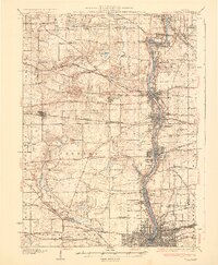
(44)- 1925 Map of Elgin
 1925 Elgin1925 Print · USGSThe Fox River valley and the surrounding Kane County prairie are captured here during the mid-twenties, a time of established rail lines and manufacturing growth. Genealogists can trace early twentieth-century schools and junctions like Munshawville School, Pingree Grove, and Hickory Grove School.4 unique versions available
 - 1932 Map of Geneva
 1932 Geneva1932 Print · USGSThe Fox River valley is a hive of early twentieth-century industry and civic life. Genealogists can trace family names through rural landmarks like Johnsons Mound or the many country schools, including Red Brick Sch and Stewart Sch.3 unique versions available
 - 1940 Map of Elgin, 1957 Print
 1940 Elgin1957 Print · USGSKane and McHenry Counties at the start of the 1940s reveal a landscape of bustling river towns and quiet prairie schools. Researchers can trace family roots through numerous local landmarks like Munshawville School, the State Hospital, and the rail junction at Huntley.
 - 1948 Map of Geneva, 1964 Print
 1948 Geneva1964 Print · USGSThe Fox River valley thrives in the late 1940s, showing the industrial cores of Geneva and Batavia before the suburban boom. Trace the complex rail network through Elburn and St Charles, or locate rural landmarks like Johnsons Mound and Red Brick Sch.
 - 1949 Map of Geneva
 1949 Geneva1949 Print · USGSThe Fox River valley in the late 1940s reveals a unique landscape of riverside industrial towns and massive state institutions. Genealogists and local historians can trace the footprint of the State Boys School, find Dunham Castle, or locate rural landmarks like Burr School.2 unique versions available
 - 1954 Map of Rockford
 1954 Rockford1954 Print · USGSThe Rock River valley and the Illinois-Wisconsin borderlands are captured here in the mid-1950s during a period of robust industrial and agricultural activity. Genealogists and historians can trace rail-era corridors like the Illinois Central RR and locate landmarks from Big Foot Prairie to Lake Geneva.
 - 1955 Map of Rockford
 1955 Rockford1955 Print · USGSThe Rock River valley and southern Wisconsin dairy country are shown here in the mid-fifties as the region's manufacturing centers grew. Genealogists and historians can trace the paths of the Chicago and North Western RR and Illinois Central RR through hubs like Rockford and Beloit.
 - 1958 Map of Aurora, 1969 Print
 1958 Aurora1969 Print · USGSNorthern Illinois in the late fifties shows a landscape of powerful river industry and expanding transport corridors. Genealogists and historians can trace the development of Aurora and Joliet or locate sites like the Elwood Ordnance Plant and Starved Rock.3 unique versions available
 - 1958 Map of Rockford, 1974 Print
 1958 Rockford1974 Print · USGSNorthern Illinois and southern Wisconsin are shown here in the mid-twentieth century as rail-dependent industrial towns began to interface with growing lakefront communities. Genealogists can trace family roots through settlements like Saylesville and Tess Corners or locate historical landmarks like the Rockford Ordnance Depot.4 unique versions available
 - 1961 Map of Aurora
 1961 Aurora1961 Print · USGSNorthern Illinois at the height of the post-war era reveals a landscape of massive industrial works and thriving river towns. Genealogists and historians can trace the paths of the Lincoln Highway or locate long-standing landmarks like the Green River Ordnance Plant and Starved Rock State Park.
 - 1962 Map of Pingree Grove, 1964 Print
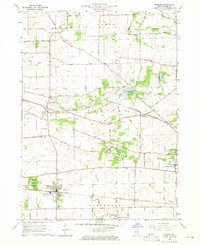
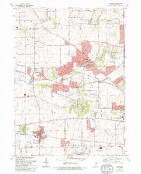
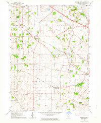 1962 Pingree Grove1964 Print · USGSNorth-central Kane County is captured in the early sixties as modern tollways began to bisect the traditional farming landscape. Researchers can trace family homesteads near Plato Center, find old schools like Central High Sch, and locate the Doty Cem burial grounds.2 unique versions available
 - 1962 Map of Elgin, 1964 Print
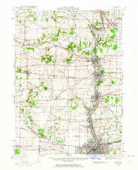
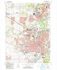
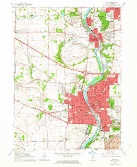 1962 Elgin1964 Print · USGSThe Fox River valley was undergoing rapid expansion in the early sixties as new highways met historic rail lines. Researchers can trace the footprints of institutional landmarks like Elgin State Hospital or locate family plots in Bluff City Cemetery.4 unique versions available
 - 1962 Map of Elgin, 1965 Print
 1962 Elgin1965 Print · USGSThe Fox River valley and the expanding Chicago suburbs are captured here in the early sixties. Genealogists and local historians can trace legacy sites like Washington Church Cemetery, the Elgin Academy, and the State Hospital Cemetery.
 - 1963 Map of Rockford
 1963 Rockford1963 Print · USGSThe mid-century industrial corridor along the Rock River is shown here during a period of rapid post-war growth. Researchers can trace the extensive rail lines of the Chicago and North Western or locate local landmarks like the Rockford Ordnance Depot and Holy Hill.
 - 1964 Map of Geneva, 1965 Print
 1964 Geneva1965 Print · USGSThe Fox River valley in the mid-1960s shows a landscape of growing river towns and sprawling forest preserves. Researchers can trace the footprints of institutional landmarks like St Dominic College or find family history at Union Cem and Oak Hill Cem.4 unique versions available
 - 1964 Map of Elburn, 1965 Print
 1964 Elburn1965 Print · USGSKane County in the mid-sixties shows a landscape of steady growth along the Chicago and North Western and Chicago Great Western railroads. Genealogists can trace family names through numerous burial sites like Lily Lake Cem or Baker Cem and explore institutions like Broadview Academy.3 unique versions available
 - 1981 Map of Elgin
 1981 Elgin1981 Print · USGSNorthern Illinois and southern Wisconsin are shown in the early eighties as suburban growth meets glacial terrain. Trace the paths of the Milwaukee Road through Harvard or explore the wetlands of Volo Bog State Natural Area.
 - 1985 Map of Aurora, 1989 Print
 1985 Aurora1989 Print · USGSNortheastern Illinois is captured in the mid-1980s as suburban growth began to bridge the gap between the Fox River cities and the outer prairies. Researchers can trace the development of Naperville and Aurora or locate rural landmarks like Fairview Cem and the Illinois and Michigan Canal.
 - 1992 Map of Pingree Grove
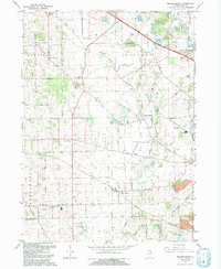 1992 Pingree Grove1992 Print · USGSKane County in the early nineties shows a landscape of steady growth where quiet townships meet major transport corridors. Genealogists and local researchers can trace family landmarks and rural life through Doty Cem, Plato Center, and Allens Corners.
 - 1992 Map of Elgin
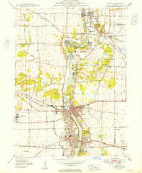
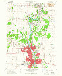
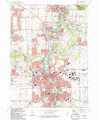
 1992 Elgin1992 Print · USGSElgin and the Fox River valley settlements are shown during a period of rapid growth in the early nineties. Researchers can trace the layout of the Elgin State Hospital, locate old family plots in Bluff City Cem, and follow the Chicago and North Western rail line.
 - 1993 Map of Elburn, 1994 Print
 1993 Elburn1994 Print · USGSKane County is captured here in the early nineties as rural townships began to interface with suburban growth. Genealogists can trace family names at Blackberry Cem or New Hampshire Cem and follow the old Chicago and North Western rail line.
 - 1993 Map of Geneva, 1994 Print
 1993 Geneva1994 Print · USGSThe Fox River valley was experiencing significant suburban expansion in the early nineties as residential neighborhoods filled the gaps between historic river towns. Researchers can trace local landmarks like Union Cem, South Elgin, and the Du Page County Airport.
 - 1998 Map of Geneva, 2002 Print
 1998 Geneva2002 Print · USGSKane County's Fox River valley is captured here at the end of the century, showing the dense growth of St Charles and Geneva. Local historians can trace old landmarks like Little Woods Cem, the Chicago and North Western rail lines, and the Illinois Prairie Path.
 - 1998 Map of Elgin, 2002 Print
 1998 Elgin2002 Print · USGSKane County suburban development is in full view during the late nineties as the region balances rapid growth with vast forest preserves. Genealogists and local historians can trace legacy landmarks like Bluff City Cemetery, Elgin State Hospital, and the rail corridor of the Chicago and North Western.
 - 2012 Map of Elgin, 2012 Print
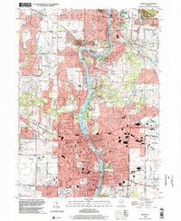
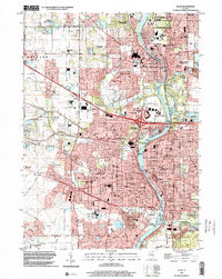
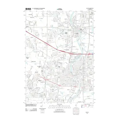 2012 Elgin2012 Print · USGSCovers Elgin Township, including Elgin, Bartlett, and other nearby areas
Showing maps 1-25 of 44
Top cities near Elgin Township
- Aurora historical maps
- Naperville historical maps
- Elgin historical maps
- Schaumburg historical maps
- Palatine historical maps
- Wayne historical maps
See more
Top neighborhoods of Elgin Township
- Udina historical maps
- Boulevard Villa historical maps
- Century Oaks West historical maps
- Clintonville historical maps
- College Green historical maps
- College Park historical maps
See more
Frequently asked questions
- What are the different types of historical maps available for Elgin Township?
- What is the oldest map of Elgin Township?
- Where can I purchase historical maps of Elgin Township for my home or office?
- Where can I download high-res historical maps of Elgin Township?
- Are there historical topographic maps available for Elgin Township?
- Is there historical aerial imagery available for Elgin Township?
- Where are historical maps of Elgin Township sourced from?