1960s Maps of Elgin, Illinois
Explore 10 historic maps of Elgin from the 1960s. These maps offer a rare glimpse into what life looked like during the 1960s — showing old roads, neighborhoods, homes, and landmarks that have changed or disappeared over time.
Whether you're researching your family's past, planning a metal detecting trip, or studying how Elgin's landscape evolved across the 1960s, these high-resolution maps are a powerful tool for exploring the history of this region.
- Focus on a specific era: All maps on this page are from the 1960s, giving you a focused view of this time period.
- See what’s changed: Compare century-old streets, trails, and buildings to today's modern landscape using overlays and satellite layers.
- Research with precision: Use these maps for genealogy, historical research, land use analysis, or educational projects.
- View, download, or print: Maps are fully viewable online in high resolution, and can be downloaded or printed for your own records.
Start exploring Elgin's history through authentic maps from the 1960s. This is your window into the past.
Elgin, IL maps
(10)- 1961 Map of Aurora
 1961 Aurora1961 Print · USGSNorthern Illinois at the height of the post-war era reveals a landscape of massive industrial works and thriving river towns. Genealogists and historians can trace the paths of the Lincoln Highway or locate long-standing landmarks like the Green River Ordnance Plant and Starved Rock State Park.
 - 1961 Map of Streamwood, 1962 Print
 1961 Streamwood1962 Print · USGSThe developing suburbs of the Chicago fringe are seen here in the early sixties as townships like Hanover and Barrington evolve. Researchers can trace the legacy of local institutions like Mission Chapel, New Era Sch, and the Drive-in Theater.5 unique versions available
 - 1961 Map of Barrington, 1965 Print
 1961 Barrington1965 Print · USGSThe northwest Chicago suburbs were in the midst of a massive post-war building boom in the early sixties. Genealogists and local historians can trace the early footprints of Hoffman Estates and Inverness, or locate landmarks like Arlington Park Racetrack and St Michael Cemetery.
 - 1962 Map of West Chicago, 1963 Print
 1962 West Chicago1963 Print · USGSMid-century DuPage County is captured here at a peak of rail activity, with five major lines crossing the prairies and developing towns. Genealogists and local historians can trace family plots at Old Ontarioville Cemetery or locate landmarks like Wheaton College Academy and the Munger rail stop.4 unique versions available
 - 1962 Map of Pingree Grove, 1964 Print
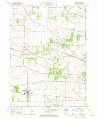
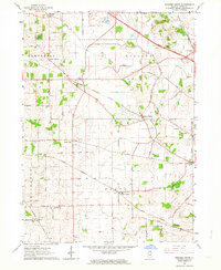 1962 Pingree Grove1964 Print · USGSNorth-central Kane County is captured in the early sixties as modern tollways began to bisect the traditional farming landscape. Researchers can trace family homesteads near Plato Center, find old schools like Central High Sch, and locate the Doty Cem burial grounds.2 unique versions available
 - 1962 Map of Elgin, 1964 Print
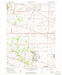
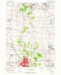
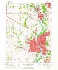 1962 Elgin1964 Print · USGSThe Fox River valley was undergoing rapid expansion in the early sixties as new highways met historic rail lines. Researchers can trace the footprints of institutional landmarks like Elgin State Hospital or locate family plots in Bluff City Cemetery.4 unique versions available
 - 1962 Map of Elgin, 1965 Print
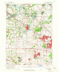
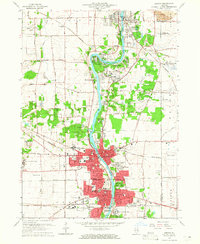
 1962 Elgin1965 Print · USGSThe Fox River valley and the expanding Chicago suburbs are captured here in the early sixties. Genealogists and local historians can trace legacy sites like Washington Church Cemetery, the Elgin Academy, and the State Hospital Cemetery.
 - 1963 Map of Rockford
 1963 Rockford1963 Print · USGSThe mid-century industrial corridor along the Rock River is shown here during a period of rapid post-war growth. Researchers can trace the extensive rail lines of the Chicago and North Western or locate local landmarks like the Rockford Ordnance Depot and Holy Hill.
 - 1964 Map of Geneva, 1965 Print
 1964 Geneva1965 Print · USGSThe Fox River valley in the mid-1960s shows a landscape of growing river towns and sprawling forest preserves. Researchers can trace the footprints of institutional landmarks like St Dominic College or find family history at Union Cem and Oak Hill Cem.4 unique versions available
 - 1964 Map of Elburn, 1965 Print
 1964 Elburn1965 Print · USGSKane County in the mid-sixties shows a landscape of steady growth along the Chicago and North Western and Chicago Great Western railroads. Genealogists can trace family names through numerous burial sites like Lily Lake Cem or Baker Cem and explore institutions like Broadview Academy.3 unique versions available
End of results
Showing maps 1-10 of 10
Top cities near Elgin
- Aurora historical maps
- Naperville historical maps
- Schaumburg historical maps
- Wayne historical maps
- Wheaton historical maps
- Hoffman Estates historical maps
See more
Frequently asked questions
- What are the different types of historical maps available for Elgin?
- What is the oldest map of Elgin?
- Where can I purchase historical maps of Elgin for my home or office?
- Where can I download high-res historical maps of Elgin?
- Are there historical topographic maps available for Elgin?
- Is there historical aerial imagery available for Elgin?
- Where are historical maps of Elgin sourced from?