1990s Maps of Elgin, Illinois
Explore 9 historic maps of Elgin from the 1990s. These maps offer a rare glimpse into what life looked like during the 1990s — showing old roads, neighborhoods, homes, and landmarks that have changed or disappeared over time.
Whether you're researching your family's past, planning a metal detecting trip, or studying how Elgin's landscape evolved across the 1990s, these high-resolution maps are a powerful tool for exploring the history of this region.
- Focus on a specific era: All maps on this page are from the 1990s, giving you a focused view of this time period.
- See what’s changed: Compare century-old streets, trails, and buildings to today's modern landscape using overlays and satellite layers.
- Research with precision: Use these maps for genealogy, historical research, land use analysis, or educational projects.
- View, download, or print: Maps are fully viewable online in high resolution, and can be downloaded or printed for your own records.
Start exploring Elgin's history through authentic maps from the 1990s. This is your window into the past.
Elgin, IL maps
(9)- 1992 Map of Pingree Grove
 1992 Pingree Grove1992 Print · USGSKane County in the early nineties shows a landscape of steady growth where quiet townships meet major transport corridors. Genealogists and local researchers can trace family landmarks and rural life through Doty Cem, Plato Center, and Allens Corners.
 - 1992 Map of Elgin
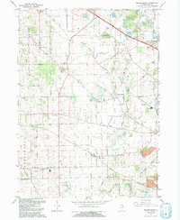
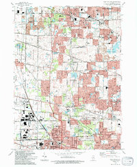
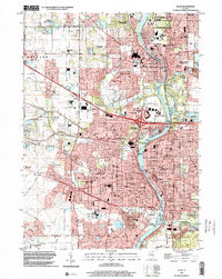
 1992 Elgin1992 Print · USGSElgin and the Fox River valley settlements are shown during a period of rapid growth in the early nineties. Researchers can trace the layout of the Elgin State Hospital, locate old family plots in Bluff City Cem, and follow the Chicago and North Western rail line.
 - 1993 Map of Elburn, 1994 Print
 1993 Elburn1994 Print · USGSKane County is captured here in the early nineties as rural townships began to interface with suburban growth. Genealogists can trace family names at Blackberry Cem or New Hampshire Cem and follow the old Chicago and North Western rail line.
 - 1993 Map of Geneva, 1994 Print
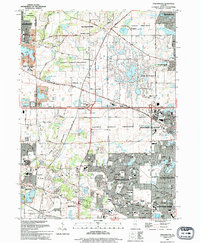
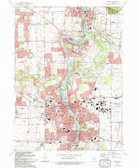 1993 Geneva1994 Print · USGSThe Fox River valley was experiencing significant suburban expansion in the early nineties as residential neighborhoods filled the gaps between historic river towns. Researchers can trace local landmarks like Union Cem, South Elgin, and the Du Page County Airport.
 - 1993 Map of West Chicago, 1994 Print
 1993 West Chicago1994 Print · USGSWest Chicago and the DuPage County borderlands show a landscape of suburban expansion and forest preservation in the early 1990s. Genealogists and local historians can trace rail-side settlements like Ontarioville, Munger, and Prince Crossing.
 - 1993 Map of Streamwood, 1994 Print
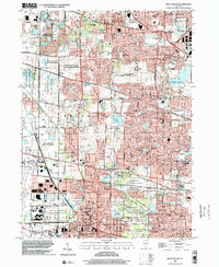
 1993 Streamwood1994 Print · USGSSuburban Cook County is captured here in the early nineties during its era of rapid residential growth. Genealogists and local historians can trace the development of Streamwood and Hoffman Estates or find local landmarks like Union Cem and Poplar Creek Theater.
 - 1998 Map of West Chicago, 2002 Print
 1998 West Chicago2002 Print · USGSDuPage County at the close of the twentieth century shows a complex network of forest preserves and suburban growth. Researchers can trace local history through sites like Wayne Twp Cem, the McAuley Sch, and the rail junction at Munger.
 - 1998 Map of Geneva, 2002 Print
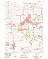
 1998 Geneva2002 Print · USGSKane County's Fox River valley is captured here at the end of the century, showing the dense growth of St Charles and Geneva. Local historians can trace old landmarks like Little Woods Cem, the Chicago and North Western rail lines, and the Illinois Prairie Path.
 - 1998 Map of Elgin, 2002 Print
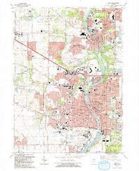
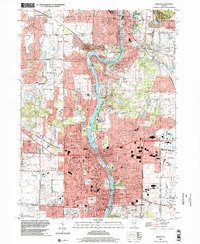
 1998 Elgin2002 Print · USGSKane County suburban development is in full view during the late nineties as the region balances rapid growth with vast forest preserves. Genealogists and local historians can trace legacy landmarks like Bluff City Cemetery, Elgin State Hospital, and the rail corridor of the Chicago and North Western.
End of results
Showing maps 1-9 of 9
Top cities near Elgin
- Aurora historical maps
- Naperville historical maps
- Schaumburg historical maps
- Wayne historical maps
- Wheaton historical maps
- Hoffman Estates historical maps
See more
Frequently asked questions
- What are the different types of historical maps available for Elgin?
- What is the oldest map of Elgin?
- Where can I purchase historical maps of Elgin for my home or office?
- Where can I download high-res historical maps of Elgin?
- Are there historical topographic maps available for Elgin?
- Is there historical aerial imagery available for Elgin?
- Where are historical maps of Elgin sourced from?