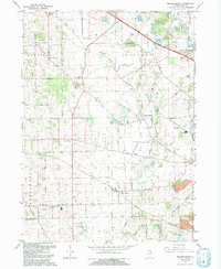
1992 Map of Pingree Grove
USGS Topo · Published 1992About this map
Plato Center and Pingree Grove anchor this 1990s agricultural and residential landscape in Kane County. The map details a period of transition where traditional farming acreage, marked by family-named routes like Dittman Road and Muirhead Road, exists alongside growing infrastructure. Educational and spiritual foundations are visible at Central High Sch and Washington Ch, while the Northwest Tollway and the Chicago and North Western railroad corridor emphasize the region's role as a transportation artery.
Find a feature on this map
59 named features on this map. Tap any name to fly to it.
Don’t see what you’re looking for? This feature index may not catch every label — zoom into the map to look around manually.
Map Details
Editions of this 1992 Pingree Grove Map
This is the sole edition of this map. No revisions or reprints were ever made.
Other maps of this area

1925 · Elgin
USGS Topo · 1:62,500

1932 · Geneva
USGS Topo · 1:62,500

1937 · Sycamore
USGS Topo · 1:62,500

1938 · Genoa
USGS Topo · 1:62,500

1940 · Elgin
USGS Topo · 1:62,500

1948 · Geneva
USGS Topo · 1:62,500

1949 · Geneva
USGS Topo · 1:24,000

1954 · Rockford
USGS Topo · 1:250,000

1955 · Rockford
USGS Topo · 1:250,000

1958 · Aurora
USGS Topo · 1:250,000