1960s Maps of Grant Park, Illinois
Explore 2 historic maps of Grant Park from the 1960s. These maps offer a rare glimpse into what life looked like during the 1960s — showing old roads, neighborhoods, homes, and landmarks that have changed or disappeared over time.
Whether you're researching your family's past, planning a metal detecting trip, or studying how Grant Park's landscape evolved across the 1960s, these high-resolution maps are a powerful tool for exploring the history of this region.
- Focus on a specific era: All maps on this page are from the 1960s, giving you a focused view of this time period.
- See what’s changed: Compare century-old streets, trails, and buildings to today's modern landscape using overlays and satellite layers.
- Research with precision: Use these maps for genealogy, historical research, land use analysis, or educational projects.
- View, download, or print: Maps are fully viewable online in high resolution, and can be downloaded or printed for your own records.
Start exploring Grant Park's history through authentic maps from the 1960s. This is your window into the past.
Grant Park, IL maps
(2)- 1963 Map of Illiana Heights, 1965 Print
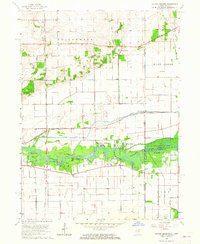 1963 Illiana Heights1965 Print · USGSThe Illinois-Indiana state line comes alive in the early sixties as riverfront life and rail junctions define the Kankakee valley. Genealogists and historians can trace riverside settlements like Garden of Eden, search for family roots at West Creek Cem, or follow the path of the NEW YORK CENTRAL railroad.3 unique versions available
 - 1964 Map of Momence, 1965 Print
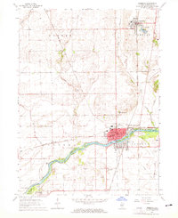 1964 Momence1965 Print · USGSMid-century Kankakee County thrives at the intersection of the Kankakee River and a powerful rail network. Genealogists and local historians can trace the foundations of Momence and Grant Park while locating rural sites like St Patricks Academy and Mount Airy Cem.3 unique versions available
End of results
Showing maps 1-2 of 2
Top cities near Grant Park
- Kankakee historical maps
- Schererville historical maps
- Park Forest historical maps
- Frankfort historical maps
- Bourbonnais historical maps
- Bradley historical maps
See more
Frequently asked questions
- What are the different types of historical maps available for Grant Park?
- What is the oldest map of Grant Park?
- Where can I purchase historical maps of Grant Park for my home or office?
- Where can I download high-res historical maps of Grant Park?
- Are there historical topographic maps available for Grant Park?
- Is there historical aerial imagery available for Grant Park?
- Where are historical maps of Grant Park sourced from?