1910s Maps of Lawrence County, Illinois
Explore 5 historic maps of Lawrence County from the 1910s. These maps offer a rare glimpse into what life looked like during the 1910s — showing old roads, neighborhoods, homes, and landmarks that have changed or disappeared over time.
Whether you're researching your family's past, planning a metal detecting trip, or studying how Lawrence County's landscape evolved across the 1910s, these high-resolution maps are a powerful tool for exploring the history of this region.
- Focus on a specific era: All maps on this page are from the 1910s, giving you a focused view of this time period.
- See what’s changed: Compare century-old streets, trails, and buildings to today's modern landscape using overlays and satellite layers.
- Research with precision: Use these maps for genealogy, historical research, land use analysis, or educational projects.
- View, download, or print: Maps are fully viewable online in high resolution, and can be downloaded or printed for your own records.
Start exploring Lawrence County's history through authentic maps from the 1910s. This is your window into the past.
Lawrence County, IL maps
(5)- 1910 Map of Hardinville
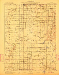 1910 Hardinville1910 Print · USGSSoutheastern Illinois at the start of the century reveals a landscape defined by the Embarrass River and early oil exploration. Genealogists can trace family roots through numerous local landmarks like Oil Center, Lucky Ford Ferry, and the Mann School.2 unique versions available
 - 1911 Map of Sumner, 1954 Print
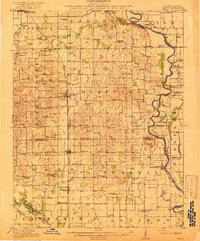
 1911 Sumner1954 Print · USGSSoutheast Illinois at the dawn of the twentieth century was a landscape of bustling rail towns and ubiquitous country schools. Genealogists can locate family-named landmarks and long-lost rural centers like Berryville, the Oil Tanks of Bridgeport, and Frogeye School.
 - 1913 Map of Sumner
 1913 Sumner1913 Print · USGSThe rural landscape of Lawrence and Richland counties is captured here just before the First World War, centered on the BALTIMORE AND OHIO SOUTHWESTERN rail line. Genealogists can locate numerous rural schools like Frogeye School and Buckhorn School or trace the early Oil Tanks near Bridgeport.2 unique versions available
 - 1915 Map of Vincennes
 1915 Vincennes1915 Print · USGSThe Wabash River valley comes to life in this early twentieth-century survey of the Illinois-Indiana border. Genealogists can trace family roots through numerous rural landmarks like St Francisville, the Sand Barrens School, and Adams Corners.5 unique versions available
 - 1917 Map of Birds
 1917 Birds1917 Print · USGSCrawford and Lawrence counties thrive along the Wabash River at the height of the rail era. Genealogists can trace family roots through dozens of local schools like Hazel Dell School and river landings such as Shaws Landing.2 unique versions available
End of results
Showing maps 1-5 of 5
Top cities of Lawrence County
- Lawrenceville historical maps
- Bridgeport historical maps
- Sumner historical maps
- Russellville historical maps
- Birds historical maps
Frequently asked questions
- What are the different types of historical maps available for Lawrence County?
- What is the oldest map of Lawrence County?
- Where can I purchase historical maps of Lawrence County for my home or office?
- Where can I download high-res historical maps of Lawrence County?
- Are there historical topographic maps available for Lawrence County?
- Is there historical aerial imagery available for Lawrence County?
- Where are historical maps of Lawrence County sourced from?