1940s Maps of Lawrence County, Illinois
Explore 5 historic maps of Lawrence County from the 1940s. These maps offer a rare glimpse into what life looked like during the 1940s — showing old roads, neighborhoods, homes, and landmarks that have changed or disappeared over time.
Whether you're researching your family's past, planning a metal detecting trip, or studying how Lawrence County's landscape evolved across the 1940s, these high-resolution maps are a powerful tool for exploring the history of this region.
- Focus on a specific era: All maps on this page are from the 1940s, giving you a focused view of this time period.
- See what’s changed: Compare century-old streets, trails, and buildings to today's modern landscape using overlays and satellite layers.
- Research with precision: Use these maps for genealogy, historical research, land use analysis, or educational projects.
- View, download, or print: Maps are fully viewable online in high resolution, and can be downloaded or printed for your own records.
Start exploring Lawrence County's history through authentic maps from the 1940s. This is your window into the past.
Lawrence County, IL maps
(5)- 1942 Map of Fritchton
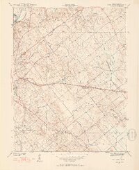 1942 Fritchton1942 Print · USGSKnox County farmland and the eastern edge of Vincennes are captured in the early 1940s as a hub of rail transit and community institutions. Researchers can locate historic local landmarks like the St Vincent Orphanage, Fritchton Cem, and the Julian Mine.2 unique versions available
 - 1942 Map of Birds, 1958 Print
 1942 Birds1958 Print · USGSThe Wabash River valley comes to life in this mid-century survey of the Illinois-Indiana borderlands. Genealogists can locate family lands near Oil Grove or trace ancestors through rural landmarks like Buncombe School and Brightlight Ferry.
 - 1943 Map of Oaktown
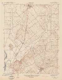 1943 Oaktown1943 Print · USGSKnox County and the Illinois borderlands come alive in the early 1940s as steam-era railroads connect the farming communities of Oaktown and Bruceville. Local historians can trace family roots through numerous sites like Ocheltree Cem, Price Cem, and the Maria Creek Ch.2 unique versions available
 - 1944 Map of Fritchton
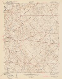 1944 Fritchton1944 Print · USGSKnox County during the mid-1940s is captured here as a crossroads of major railroads and farming townships just east of the Wabash. Local historians can trace the foundations of the community at the St Vincent Orphanage or follow the legacy of the Julian Mine and Royal Oak Ch.2 unique versions available
 - 1944 Map of Vincennes, 1958 Print
 1944 Vincennes1958 Print · USGSThe Wabash River valley during the mid-1940s reveals a landscape of river-town commerce and rural school districts. Genealogists can trace family roots through numerous sites like St Thomas church, the Bunker Hill School, and the small settlement at Billett.
End of results
Showing maps 1-5 of 5
Top cities of Lawrence County
- Lawrenceville historical maps
- Bridgeport historical maps
- Sumner historical maps
- Russellville historical maps
- Birds historical maps
Frequently asked questions
- What are the different types of historical maps available for Lawrence County?
- What is the oldest map of Lawrence County?
- Where can I purchase historical maps of Lawrence County for my home or office?
- Where can I download high-res historical maps of Lawrence County?
- Are there historical topographic maps available for Lawrence County?
- Is there historical aerial imagery available for Lawrence County?
- Where are historical maps of Lawrence County sourced from?