1910s Maps of Chestervale, Illinois
Explore 2 historic maps of Chestervale from the 1910s. These maps offer a rare glimpse into what life looked like during the 1910s — showing old roads, neighborhoods, homes, and landmarks that have changed or disappeared over time.
Whether you're researching your family's past, planning a metal detecting trip, or studying how Chestervale's landscape evolved across the 1910s, these high-resolution maps are a powerful tool for exploring the history of this region.
- Focus on a specific era: All maps on this page are from the 1910s, giving you a focused view of this time period.
- See what’s changed: Compare century-old streets, trails, and buildings to today's modern landscape using overlays and satellite layers.
- Research with precision: Use these maps for genealogy, historical research, land use analysis, or educational projects.
- View, download, or print: Maps are fully viewable online in high resolution, and can be downloaded or printed for your own records.
Start exploring Chestervale's history through authentic maps from the 1910s. This is your window into the past.
Chestervale, IL maps
(2)- 1911 Map of Lincoln, 1967 Print
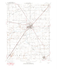 1911 Lincoln1967 Print · USGSLogan County at the dawn of the automotive age shows a landscape defined by rail lines and one-room schoolhouses. Genealogists can trace family footprints at Rose Hill Cemetery or locate ancestral farm sites near Hartsburg, Broadwell, and Mount Pulaski.
 - 1913 Map of Lincoln
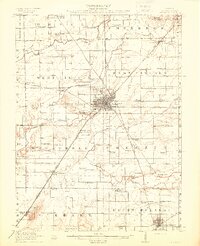 1913 Lincoln1913 Print · USGSLogan County’s agricultural and rail heartland is captured here just before the Great War. Genealogists can locate family lands near dozens of rural schools like Sigg School or trace the early electric ILLINOIS TRACTION SYSTEM through Broadwell.3 unique versions available
End of results
Showing maps 1-2 of 2
Top cities near Chestervale
- Lincoln historical maps
- Atlanta historical maps
- Mount Pulaski historical maps
- Williamsville historical maps
- Spaulding historical maps
- McLean historical maps
See more
Frequently asked questions
- What are the different types of historical maps available for Chestervale?
- What is the oldest map of Chestervale?
- Where can I purchase historical maps of Chestervale for my home or office?
- Where can I download high-res historical maps of Chestervale?
- Are there historical topographic maps available for Chestervale?
- Is there historical aerial imagery available for Chestervale?
- Where are historical maps of Chestervale sourced from?