1930s Maps of Marion County, Illinois
Explore 4 historic maps of Marion County from the 1930s. These maps offer a rare glimpse into what life looked like during the 1930s — showing old roads, neighborhoods, homes, and landmarks that have changed or disappeared over time.
Whether you're researching your family's past, planning a metal detecting trip, or studying how Marion County's landscape evolved across the 1930s, these high-resolution maps are a powerful tool for exploring the history of this region.
- Focus on a specific era: All maps on this page are from the 1930s, giving you a focused view of this time period.
- See what’s changed: Compare century-old streets, trails, and buildings to today's modern landscape using overlays and satellite layers.
- Research with precision: Use these maps for genealogy, historical research, land use analysis, or educational projects.
- View, download, or print: Maps are fully viewable online in high resolution, and can be downloaded or printed for your own records.
Start exploring Marion County's history through authentic maps from the 1930s. This is your window into the past.
Marion County, IL maps
(4)- 1933 Map of Mount Vernon
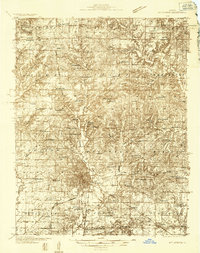 1933 Mount Vernon1933 Print · USGSMount Vernon and the surrounding Jefferson County countryside are captured here in the early 1930s as a vital crossroads of rail and road. Genealogists can trace family roots through dozens of rural landmarks like Old Shiloh Ch, George College Sch, and Atkinson Cem.3 unique versions available
 - 1934 Map of Salem, 1960 Print
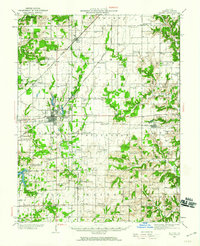 1934 Salem1960 Print · USGSMarion County in the mid-1930s is a dense network of steam railroads and rural township life centered around the bustling city of Salem. Genealogists and historians can trace family roots at numerous rural schoolhouses like Allmon Sch and historic landmarks such as the County Infirmary.
 - 1935 Map of Centralia, 1958 Print
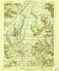
 1935 Centralia1958 Print · USGSCentralia and the surrounding Marion County townships thrived as a major railroad crossroads in the mid-1930s. Researchers can locate dozens of localized rural schoolhouses like Red Stripe and Possumtrot School or trace the early paths of the Illinois Central through Sandoval and Odin.
 - 1938 Map of Salem
 1938 Salem1938 Print · USGSMarion County thrived as a rail-centric agricultural hub in the late 1930s, defined by the intersection of three major railroads. Genealogists can trace family roots through dozens of local landmarks like Givens Chapel, County Infirmary, and the Martin Cem.2 unique versions available
End of results
Showing maps 1-4 of 4
Top cities of Marion County
- Centralia historical maps
- Salem historical maps
- Sandoval historical maps
- Central City historical maps
- Odin historical maps
- Tonti historical maps
See more
Frequently asked questions
- What are the different types of historical maps available for Marion County?
- What is the oldest map of Marion County?
- Where can I purchase historical maps of Marion County for my home or office?
- Where can I download high-res historical maps of Marion County?
- Are there historical topographic maps available for Marion County?
- Is there historical aerial imagery available for Marion County?
- Where are historical maps of Marion County sourced from?