1970s Maps of Marion County, Illinois
Explore 7 historic maps of Marion County from the 1970s. These maps offer a rare glimpse into what life looked like during the 1970s — showing old roads, neighborhoods, homes, and landmarks that have changed or disappeared over time.
Whether you're researching your family's past, planning a metal detecting trip, or studying how Marion County's landscape evolved across the 1970s, these high-resolution maps are a powerful tool for exploring the history of this region.
- Focus on a specific era: All maps on this page are from the 1970s, giving you a focused view of this time period.
- See what’s changed: Compare century-old streets, trails, and buildings to today's modern landscape using overlays and satellite layers.
- Research with precision: Use these maps for genealogy, historical research, land use analysis, or educational projects.
- View, download, or print: Maps are fully viewable online in high resolution, and can be downloaded or printed for your own records.
Start exploring Marion County's history through authentic maps from the 1970s. This is your window into the past.
Marion County, IL maps
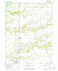
(7)- 1970 Map of Fairman, 1971 Print
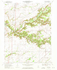 1970 Fairman1971 Print · USGSMarion County's rural oil-producing landscape is captured here in the early seventies as the petroleum industry shaped the local economy. Researchers can locate the Patoka East Oil Field, the Illinois Central railroad, and family landmarks like Cruise Cem and Cubbage Chapel.
 - 1970 Map of Centralia East, 1971 Print
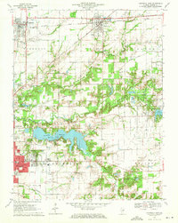 1970 Centralia East1971 Print · USGSMarion County at the start of the 1970s reveals a landscape of industrial energy and deep-rooted rural communities. Trace the intersection of the Illinois Central railroad with local landmarks like the Raccoon Lake Oil Field and Peaceful Valley Cem.3 unique versions available
 - 1973 Map of Shields, 1975 Print
 1973 Shields1975 Print · USGSWayne and Jefferson counties come alive in the early seventies, showing a landscape defined by the Orchardville Oil Field and rural river crossings. Trace family roots at the McConaughhay Cem, locate the old Ten Foot Oak Ch, or follow the Skillet Fork to Greathouse Ford.
 - 1974 Map of Wildcat Lake, 1977 Print
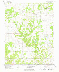
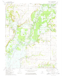 1974 Wildcat Lake1977 Print · USGSMid-century Illinois comes to life in this survey of the river bottomlands during the development of the Carlyle Lake conservation system. Genealogists and historians can trace family roots through numerous sites like Williams Cem, Mound Chapel, and the Patoka Oil Field.2 unique versions available
 - 1974 Map of Patoka, 1977 Print
 1974 Patoka1977 Print · USGSMarion and Fayette Counties show a landscape defined by petroleum extraction and rail transport in the mid-1970s. Researchers can trace family history through local sites like Patoka Sch or the Farmers Cem and Hatch Cem.2 unique versions available
 - 1974 Map of Walnut Hill, 1978 Print
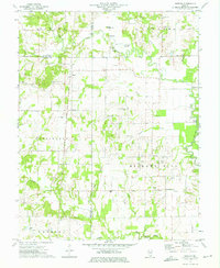
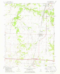
 1974 Walnut Hill1978 Print · USGSMarion and Jefferson counties are shown here in the mid-seventies, captured at the intersection of the regional railroad network and the local oil industry. Researchers can trace family sites at Gaston Cem, Grand Prairie Sch, and the small settlement of Cravat.
 - 1974 Map of Irvington, 1978 Print
 1974 Irvington1978 Print · USGSSouthern Illinois oil production and rail transport define this mid-1970s landscape near the Washington and Jefferson county line. Trace local history through the Irvington Oil Field, the Gulf Mobile and Ohio railroad, and family-named sites like Harres Cemetery.
End of results
Showing maps 1-7 of 7
Top cities of Marion County
- Centralia historical maps
- Salem historical maps
- Sandoval historical maps
- Central City historical maps
- Odin historical maps
- Tonti historical maps
See more
Frequently asked questions
- What are the different types of historical maps available for Marion County?
- What is the oldest map of Marion County?
- Where can I purchase historical maps of Marion County for my home or office?
- Where can I download high-res historical maps of Marion County?
- Are there historical topographic maps available for Marion County?
- Is there historical aerial imagery available for Marion County?
- Where are historical maps of Marion County sourced from?