1950s Maps of Toluca, Illinois
Explore 3 historic maps of Toluca from the 1950s. These maps offer a rare glimpse into what life looked like during the 1950s — showing old roads, neighborhoods, homes, and landmarks that have changed or disappeared over time.
Whether you're researching your family's past, planning a metal detecting trip, or studying how Toluca's landscape evolved across the 1950s, these high-resolution maps are a powerful tool for exploring the history of this region.
- Focus on a specific era: All maps on this page are from the 1950s, giving you a focused view of this time period.
- See what’s changed: Compare century-old streets, trails, and buildings to today's modern landscape using overlays and satellite layers.
- Research with precision: Use these maps for genealogy, historical research, land use analysis, or educational projects.
- View, download, or print: Maps are fully viewable online in high resolution, and can be downloaded or printed for your own records.
Start exploring Toluca's history through authentic maps from the 1950s. This is your window into the past.
Toluca, IL maps
(3)- 1955 Map of Minonk, 1956 Print
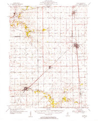 1955 Minonk1956 Print · USGSWoodford and Marshall counties at mid-century reveal a thriving rail-and-coal economy across the Illinois prairie. Family researchers and historians can trace lineage at Mennonite Ch, find old Mine Dumps, or locate vanished landmarks like Spring Hill Sch.
 - 1958 Map of Aurora, 1969 Print
 1958 Aurora1969 Print · USGSNorthern Illinois in the late fifties shows a landscape of powerful river industry and expanding transport corridors. Genealogists and historians can trace the development of Aurora and Joliet or locate sites like the Elwood Ordnance Plant and Starved Rock.3 unique versions available
 - 1958 Map of Peoria, 1969 Print
 1958 Peoria1969 Print · USGSCentral Illinois thrived as a hub of education and transport during the late sixties, as the new interstate system began to reshape the prairie. Genealogists and historians can trace local landmarks like Springdale Cem, Bradley University, and the sprawling grounds of Chanute AFB.4 unique versions available
End of results
Showing maps 1-3 of 3
Top cities near Toluca
- Metamora historical maps
- Henry historical maps
- Minonk historical maps
- Roanoke historical maps
- Cazenovia historical maps
- Evans historical maps
See more
Frequently asked questions
- What are the different types of historical maps available for Toluca?
- What is the oldest map of Toluca?
- Where can I purchase historical maps of Toluca for my home or office?
- Where can I download high-res historical maps of Toluca?
- Are there historical topographic maps available for Toluca?
- Is there historical aerial imagery available for Toluca?
- Where are historical maps of Toluca sourced from?