1990s Maps of Brookport, Illinois
Explore 2 historic maps of Brookport from the 1990s. These maps offer a rare glimpse into what life looked like during the 1990s — showing old roads, neighborhoods, homes, and landmarks that have changed or disappeared over time.
Whether you're researching your family's past, planning a metal detecting trip, or studying how Brookport's landscape evolved across the 1990s, these high-resolution maps are a powerful tool for exploring the history of this region.
- Focus on a specific era: All maps on this page are from the 1990s, giving you a focused view of this time period.
- See what’s changed: Compare century-old streets, trails, and buildings to today's modern landscape using overlays and satellite layers.
- Research with precision: Use these maps for genealogy, historical research, land use analysis, or educational projects.
- View, download, or print: Maps are fully viewable online in high resolution, and can be downloaded or printed for your own records.
Start exploring Brookport's history through authentic maps from the 1990s. This is your window into the past.
Brookport, IL maps
(2)- 1996 Map of Metropolis, 1998 Print
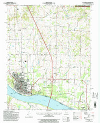 1996 Metropolis1998 Print · USGSThe Ohio River waterfront at Metropolis in the late nineties showcases a blend of civic infrastructure and protected public lands. Local historians can trace family roots through numerous sites like Odd Fellows Cem, Upper Salem Ch, and Fort Massac State Park.
 - 1996 Map of Paducah NE, 1998 Print
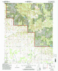 1996 Paducah NE1998 Print · USGSMassac County and the Shawnee National Forest appear here in the mid-1990s, just as modern imagery updated the record of this rural landscape. Genealogists and local historians can locate dozens of small landmarks, from Unity Sch and Mt Sterling Ch to family burial sites like Golightly Cem and Pell Cem.2 unique versions available
End of results
Showing maps 1-2 of 2
Top cities near Brookport
- Paducah historical maps
- Metropolis historical maps
- Reidland historical maps
- Calvert City historical maps
- Golconda historical maps
- Lone Oak historical maps
See more
Frequently asked questions
- What are the different types of historical maps available for Brookport?
- What is the oldest map of Brookport?
- Where can I purchase historical maps of Brookport for my home or office?
- Where can I download high-res historical maps of Brookport?
- Are there historical topographic maps available for Brookport?
- Is there historical aerial imagery available for Brookport?
- Where are historical maps of Brookport sourced from?