1990s Maps of McDonough County, Illinois
Explore 6 historic maps of McDonough County from the 1990s. These maps offer a rare glimpse into what life looked like during the 1990s — showing old roads, neighborhoods, homes, and landmarks that have changed or disappeared over time.
Whether you're researching your family's past, planning a metal detecting trip, or studying how McDonough County's landscape evolved across the 1990s, these high-resolution maps are a powerful tool for exploring the history of this region.
- Focus on a specific era: All maps on this page are from the 1990s, giving you a focused view of this time period.
- See what’s changed: Compare century-old streets, trails, and buildings to today's modern landscape using overlays and satellite layers.
- Research with precision: Use these maps for genealogy, historical research, land use analysis, or educational projects.
- View, download, or print: Maps are fully viewable online in high resolution, and can be downloaded or printed for your own records.
Start exploring McDonough County's history through authentic maps from the 1990s. This is your window into the past.
McDonough County, IL maps
(6)- 1990 Map of Burlington
 1990 Burlington1990 Print · USGSThe tri-state confluence of Iowa, Illinois, and Missouri is mapped here at the end of the twentieth century. Genealogists and historians can trace the riverfront heritage of Burlington, Keokuk, and Fort Madison, or locate sites like the Battle of Athens State Historic Site.2 unique versions available
 - 1997 Map of Macomb, 1999 Print
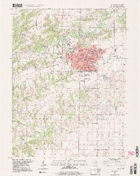 1997 Macomb1999 Print · USGSMacomb serves as a bustling university and county seat in the late nineties, balancing academic growth with its deep agricultural roots. Researchers can trace family history through numerous burial sites like Oakwood Cem or locate local landmarks like Western Illinois University and the central Courthouse.2 unique versions available
 - 1998 Map of Good Hope, 2000 Print
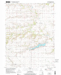
 1998 Good Hope2000 Print · USGSWestern Illinois agricultural lands and growing municipal centers are captured here in the late nineties. Genealogists and local historians can trace family plots at Hickory Grove Cemetery or explore the developments near Spring Lake and Good Hope.
 - 1998 Map of Roseville, 2000 Print
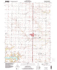
 1998 Roseville2000 Print · USGSWestern Illinois prairie and stream valleys come into focus in the late nineties as the village of Roseville anchors the surrounding townships. Researchers can trace rural lineages through local landmarks like Point Pleasant Cemetery, the Townhall, and several rural burial grounds including Asbury Cemetery.
 - 1998 Map of Avon, 2001 Print
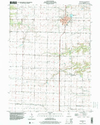
 1998 Avon2001 Print · USGSNear the borders of four Illinois counties in the late 1990s, this area centers on the rail-and-farming community of Avon. Genealogists can trace local roots at St Augustine Cem, Holeman Cem, and Prairie City Cem, or locate landmarks like Saunders Hospital.
 - 1998 Map of Greenbush, 2001 Print
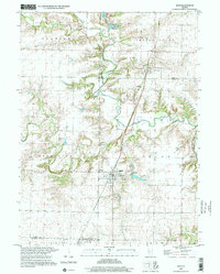
 1998 Greenbush2001 Print · USGSThe rural landscapes of western Illinois are captured here in the late twentieth century as agriculture and natural drainage basins define the region. Genealogists can locate several family burial grounds including Greenbush Cem, McMahill Cem, and Bond Cem near the waters of Swan Lake.
End of results
Showing maps 1-6 of 6
Top cities of McDonough County
- Macomb historical maps
- Bushnell historical maps
- Colchester historical maps
- Blandinsville historical maps
- Industry historical maps
- Walnut Grove historical maps
See more
Frequently asked questions
- What are the different types of historical maps available for McDonough County?
- What is the oldest map of McDonough County?
- Where can I purchase historical maps of McDonough County for my home or office?
- Where can I download high-res historical maps of McDonough County?
- Are there historical topographic maps available for McDonough County?
- Is there historical aerial imagery available for McDonough County?
- Where are historical maps of McDonough County sourced from?