1970s Maps of McDonough County, Illinois
Explore 18 historic maps of McDonough County from the 1970s. These maps offer a rare glimpse into what life looked like during the 1970s — showing old roads, neighborhoods, homes, and landmarks that have changed or disappeared over time.
Whether you're researching your family's past, planning a metal detecting trip, or studying how McDonough County's landscape evolved across the 1970s, these high-resolution maps are a powerful tool for exploring the history of this region.
- Focus on a specific era: All maps on this page are from the 1970s, giving you a focused view of this time period.
- See what’s changed: Compare century-old streets, trails, and buildings to today's modern landscape using overlays and satellite layers.
- Research with precision: Use these maps for genealogy, historical research, land use analysis, or educational projects.
- View, download, or print: Maps are fully viewable online in high resolution, and can be downloaded or printed for your own records.
Start exploring McDonough County's history through authentic maps from the 1970s. This is your window into the past.
McDonough County, IL maps
(18)- 1974 Map of Doddsville, 1977 Print
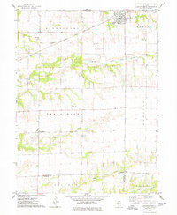
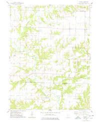
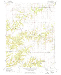 1974 Doddsville1977 Print · USGSThe McDonough and Schuyler County line in the mid-1970s is a landscape of winding creek valleys and high ridges. Researchers can trace local history through numerous burial sites like Stoneking Cem and Pennington Cem or locate the Strip Mine near Grindstone Creek.
 - 1974 Map of Bardolph, 1977 Print
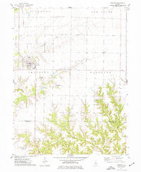
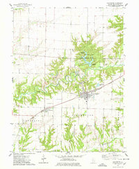
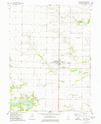
 1974 Bardolph1977 Print · USGSBardolph and the surrounding McDonough County countryside are captured here in the mid-1970s, showing a landscape defined by prairie agriculture and rail transit. Researchers can locate community anchors like Camp Creek Ch, the Mound Cem, and the historic settlement at Pennington Point.
 - 1974 Map of Industry, 1977 Print
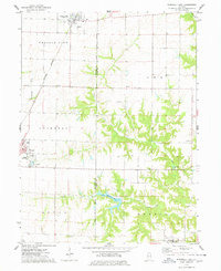
 1974 Industry1977 Print · USGSMcDonough and Schuyler Counties in the mid-seventies show a landscape of traditional township farming and rural church life. Genealogists can trace family names through sites like Peck Cem, Standard Cem, and the West Prairie Ch.
 - 1974 Map of Macomb, 1977 Print
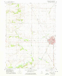
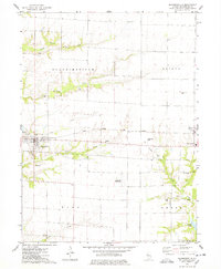
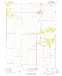
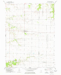
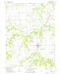
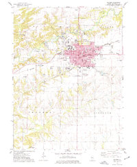 1974 Macomb1977 Print · USGSMacomb and its surrounding townships thrive in the mid-1970s as a major educational and rail hub. Genealogists can trace family names through Oakwood Cem and Wayland Cem, or locate historic schools like Woodrow Wilson Sch and Lincoln Sch.3 unique versions available
 - 1974 Map of Fountain Green, 1978 Print
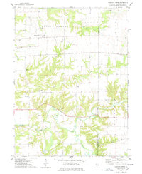 1974 Fountain Green1978 Print · USGSHancock and McDonough Counties are shown in the mid-1970s, a landscape where rural township life centers on small crossroads and winding creek systems. Genealogists can locate several family burial grounds like Lincoln Cem and Yetter Cem, alongside landmarks like Majorville Ch.
 - 1974 Map of Stronghurst, 1978 Print
 1974 Stronghurst1978 Print · USGSWestern Illinois farmland and the villages along the Santa Fe and Topeka Atchison railroad appear in this mid-seventies survey. Researchers can locate remote rural sites like the Old Bedford Ch, Smith Landing Strip, and Peasley Cem.
 - 1974 Map of Colchester, 1978 Print
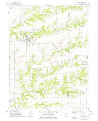
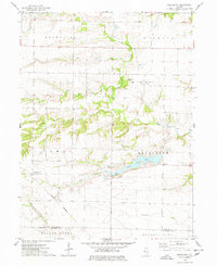
 1974 Colchester1978 Print · USGSColchester and the surrounding prairie of McDonough County are captured in the mid-1970s, as the local economy balanced agriculture with riverfront industry. Trace family roots at Mt Auburn Cemetery or Lower Cem, and explore the land around Argyle Lake State Park and the Burlington Northern line.
 - 1974 Map of Bushnell East, 1978 Print
 1974 Bushnell East1978 Print · USGSPrairie City and Bushnell sit at a vital rail crossroads during the mid-seventies, where agriculture meets early recreational development. Trace local lineage and industry through Mound Cem, the First Baptist Ch, and a large Strip Mine.
 - 1974 Map of Bushnell West, 1978 Print
 1974 Bushnell West1978 Print · USGSMid-century McDonough County is defined here by its intersection of rail and river during the 1970s. Trace the rural landscape through family landmarks like Hageman Cem or the industrial corridors of the Toledo Peoria and Western and Burlington Northern railroads.
 - 1974 Map of Blandinsville, 1978 Print
 1974 Blandinsville1978 Print · USGSBlandinsville and the surrounding McDonough County prairie are shown in the mid-1970s as a landscape of productive agriculture and emerging infrastructure. Researchers can locate numerous rural burial sites like South Cem and Guy Cem, or trace the Toledo Peoria and Western rail line.
 - 1974 Map of Roseville, 1978 Print
 1974 Roseville1978 Print · USGSThe agricultural plains of Warren County are shown in detail during the mid-seventies, centered on the village of Roseville. Genealogists and local historians can locate several rural burial grounds such as Memorial Park Cem and Point Pleasant Cem, alongside the Burlington Northern rail line.
 - 1974 Map of Avon, 1978 Print
 1974 Avon1978 Print · USGSThe rail-corridor communities of west-central Illinois are documented here in the mid-1970s as they transition into the late twentieth century. Researchers can locate numerous family-named burial grounds like Babbitt Cem or trace the rural footprint of Saunders Hospital and the Long Landing Strip.
 - 1974 Map of Raritan, 1978 Print
 1974 Raritan1978 Print · USGSRaritan and the surrounding prairie townships are captured here in the mid-1970s, showcasing the intersection of three Illinois counties. Researchers can trace land divisions and local landmarks like St Patricks Ch and the headwaters of the La Moine River.
 - 1974 Map of La Harpe, 1978 Print
 1974 La Harpe1978 Print · USGSLa Harpe and Blandinsville sit at the heart of this mid-1970s Illinois survey, which details the agricultural landscape along the Hancock and McDonough county line. Genealogists and rail historians can trace the Toledo Peoria and Western line or locate rural sites like Chapel Cem and the Landing Field.
 - 1974 Map of Fandon, 1978 Print
 1974 Fandon1978 Print · USGSThe western Illinois borderlands of McDonough and Schuyler counties appear here in the mid-1970s, defined by the winding La Moine River. Genealogists and historians can locate rural landmarks like the White Flock Cem, the Colmar - Plymouth Oil Field, and the settlement of Birmingham.
 - 1974 Map of Good Hope, 1978 Print
 1974 Good Hope1978 Print · USGSMcDonough County’s agricultural heartland is documented in the mid-seventies just as modern infrastructure began to expand around the rural townships. Genealogists and local historians can locate Good Hope Cem, Sciota, and the grounds of Camp Chic-A-Gami.
 - 1974 Map of Greenbush, 1978 Print
 1974 Greenbush1978 Print · USGSThe rural borderlands of Warren and McDonough counties are captured here in the mid-1970s, showing a landscape of small townships and prairie creeks. Genealogists can locate family-named sites like McMahill Cem and Bond Cem or trace the Burlington Northern line near Youngstown.
 - 1974 Map of Plymouth, 1978 Print
 1974 Plymouth1978 Print · USGSHancock and McDonough counties meet here in the mid-1970s, where rural industry and rail lines converge. Genealogists and historians can trace the Colmar - Plymouth Oil Field and family sites like Trimble Cem or Irwin Cem.
End of results
Showing maps 1-18 of 18
Top cities of McDonough County
- Macomb historical maps
- Bushnell historical maps
- Colchester historical maps
- Blandinsville historical maps
- Industry historical maps
- Walnut Grove historical maps
See more
Frequently asked questions
- What are the different types of historical maps available for McDonough County?
- What is the oldest map of McDonough County?
- Where can I purchase historical maps of McDonough County for my home or office?
- Where can I download high-res historical maps of McDonough County?
- Are there historical topographic maps available for McDonough County?
- Is there historical aerial imagery available for McDonough County?
- Where are historical maps of McDonough County sourced from?