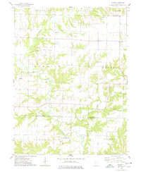
1974 Map of Fandon
USGS Topo · Published 1978About this map
The Colmar - Plymouth Oil Field dominates the western uplands of this mid-1970s landscape, where numerous Oil Wells dot the terrain north of the La Moine River. This extractive economy exists alongside a deeply rooted agricultural and religious community, evidenced by a high density of country churches and family burial grounds. Notable landmarks for local historians include the White Flock Ch and its adjacent White Flock Cem, as well as the Dunkard Cem situated near the headwaters of Grindstone Creek. The map also captures the small settlements of Fandon in the north and Birmingham in the south, the latter positioned near the confluence of Flour Creek and the river. The topography is defined by the winding river valley and its many tributaries, including Troublesome Creek and Camp Creek, which carve through the townships of Tennessee, Chalmers, and Brooklyn.
Find a feature on this map
28 named features on this map. Tap any name to fly to it.
Don’t see what you’re looking for? This feature index may not catch every label — zoom into the map to look around manually.
Map Details
Editions of this 1974 Fandon Map
This is the sole edition of this map. No revisions or reprints were ever made.
Other maps of this area

1912 · Macomb
USGS Topo · 1:62,500

1913 · Colchester
USGS Topo · 1:62,500

1914 · Macomb
USGS Topo · 1:62,500

1923 · Rushville
USGS Topo · 1:62,500

1926 · Rushville
USGS Topo · 1:62,500

1946 · Augusta
USGS Topo · 1:62,500

1949 · Augusta
USGS Topo · 1:62,500

1958 · Burlington
USGS Topo · 1:250,000

1961 · Burlington
USGS Topo · 1:250,000

1963 · Burlington
USGS Topo · 1:250,000