1990s Maps of Waterloo, Illinois
Explore 3 historic maps of Waterloo from the 1990s. These maps offer a rare glimpse into what life looked like during the 1990s — showing old roads, neighborhoods, homes, and landmarks that have changed or disappeared over time.
Whether you're researching your family's past, planning a metal detecting trip, or studying how Waterloo's landscape evolved across the 1990s, these high-resolution maps are a powerful tool for exploring the history of this region.
- Focus on a specific era: All maps on this page are from the 1990s, giving you a focused view of this time period.
- See what’s changed: Compare century-old streets, trails, and buildings to today's modern landscape using overlays and satellite layers.
- Research with precision: Use these maps for genealogy, historical research, land use analysis, or educational projects.
- View, download, or print: Maps are fully viewable online in high resolution, and can be downloaded or printed for your own records.
Start exploring Waterloo's history through authentic maps from the 1990s. This is your window into the past.
Waterloo, IL maps
(3)- 1990 Map of Paderborn, 1991 Print
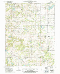 1990 Paderborn1991 Print · USGSSouthwestern Illinois farm country comes into focus in the 1990s as it appeared before suburban expansion reached these rural townships. Genealogists can trace family names through sites like Martini Cem, St Michaels Ch, and the old Burksville Station settlement.
 - 1991 Map of Waterloo
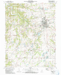 1991 Waterloo1991 Print · USGSThe area around Waterloo is shown in the early nineties, revealing a landscape of established town streets and dispersed rural settlements. Genealogists can locate family landmarks at SS Peter and Paul Cem or the Old Rock Sch.
 - 1991 Map of Columbia
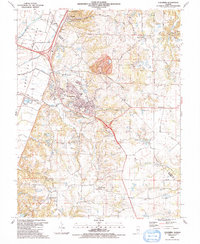 1991 Columbia1991 Print · USGSMonroe County and the American Bottoms are captured in the early 1990s as industrial sites and quiet rural settlements coexist. Genealogists can trace family names and locations at City Cem, St Pauls Ch, and the Cement Hollow Oil Field.
End of results
Showing maps 1-3 of 3
Top cities near Waterloo
- Belleville historical maps
- Oakville historical maps
- O'Fallon historical maps
- Mehlville historical maps
- Webster Groves historical maps
- Arnold historical maps
See more
Frequently asked questions
- What are the different types of historical maps available for Waterloo?
- What is the oldest map of Waterloo?
- Where can I purchase historical maps of Waterloo for my home or office?
- Where can I download high-res historical maps of Waterloo?
- Are there historical topographic maps available for Waterloo?
- Is there historical aerial imagery available for Waterloo?
- Where are historical maps of Waterloo sourced from?