1970s Maps of Litchfield, Illinois
Explore 3 historic maps of Litchfield from the 1970s. These maps offer a rare glimpse into what life looked like during the 1970s — showing old roads, neighborhoods, homes, and landmarks that have changed or disappeared over time.
Whether you're researching your family's past, planning a metal detecting trip, or studying how Litchfield's landscape evolved across the 1970s, these high-resolution maps are a powerful tool for exploring the history of this region.
- Focus on a specific era: All maps on this page are from the 1970s, giving you a focused view of this time period.
- See what’s changed: Compare century-old streets, trails, and buildings to today's modern landscape using overlays and satellite layers.
- Research with precision: Use these maps for genealogy, historical research, land use analysis, or educational projects.
- View, download, or print: Maps are fully viewable online in high resolution, and can be downloaded or printed for your own records.
Start exploring Litchfield's history through authentic maps from the 1970s. This is your window into the past.
Litchfield, IL maps
(3)- 1974 Map of Butler, 1977 Print
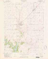
 1974 Butler1977 Print · USGSThe northern edge of Hillsboro and the rural township of Butler Grove are documented in the mid-seventies. Researchers can locate local landmarks like Wares Grove Ch and Cress Hill Cem, or trace the ABANDONED rail line near Butler.
 - 1974 Map of Litchfield, 1977 Print
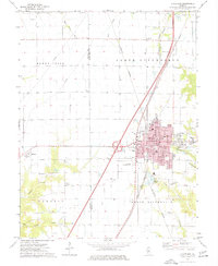 1974 Litchfield1977 Print · USGSLitchfield and its surrounding townships are captured in the mid-seventies, showing the intersection of heavy rail lines and the growing interstate system. Researchers can trace family sites at Karnes Cem and Trinity Ch, or locate local landmarks like the Drive-in Theater and the Litchfield Municipal Airport.
 - 1979 Map of Raymond, 1980 Print
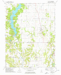
 1979 Raymond1980 Print · USGSThe Montgomery County prairie is shown here during the late 1970s, as agricultural townships surround the northern waters of the local reservoir. Genealogists can locate family landmarks like Asbury Cem and Cass Cem or trace the Norfolk and Western rail corridor.2 unique versions available
End of results
Showing maps 1-3 of 3
Top cities near Litchfield
- Hillsboro historical maps
- Carlinville historical maps
- Staunton historical maps
- Gillespie historical maps
- Mount Olive historical maps
- Benld historical maps
See more
Top neighborhoods of Litchfield
Frequently asked questions
- What are the different types of historical maps available for Litchfield?
- What is the oldest map of Litchfield?
- Where can I purchase historical maps of Litchfield for my home or office?
- Where can I download high-res historical maps of Litchfield?
- Are there historical topographic maps available for Litchfield?
- Is there historical aerial imagery available for Litchfield?
- Where are historical maps of Litchfield sourced from?