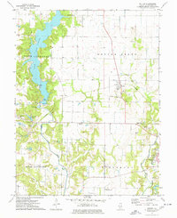
1974 Map of Butler
USGS Topo · Published 1977About this map
The northern reaches of Hillsboro and the rural village of Butler define the landscape of this mid-1970s survey in Montgomery County. This era captures the significant local impact of Lake Lou Yaeger, showing recreational infrastructure like the Picnic Area and Boat Ramp alongside the Litchfield Lake area. The map illustrates a transitional period for regional transport, where an Abandoned rail line cuts through the center of the sheet, and the Old RR Grade south of Chautauqua Lake marks the former paths of industry. For those looking for family history, the map is densely marked with local landmarks, from the Wares Grove Ch to several traditional burial grounds including Butler Cem and Oak Grove Cem. The agricultural and industrial character is further grounded by numerous Gravel Pits and a Claypit scattered across the township of Butler Grove.
Find a feature on this map
39 named features on this map. Tap any name to fly to it.
Don’t see what you’re looking for? This feature index may not catch every label — zoom into the map to look around manually.
Map Details
Editions of this 1974 Butler Map
This is the sole edition of this map. No revisions or reprints were ever made.
Other maps of this area

1915 · Mount Olive
USGS Topo · 1:62,500

1923 · Raymond
USGS Topo · 1:62,500

1925 · Raymond
USGS Topo · 1:62,500

1944 · Mount Olive
USGS Topo · 1:62,500

1946 · Nokomis
USGS Topo · 1:62,500

1947 · Hillsboro
USGS Topo · 1:62,500

1949 · Hillsboro
USGS Topo · 1:62,500

1949 · Nokomis
USGS Topo · 1:62,500

1958 · Decatur
USGS Topo · 1:250,000

1961 · Decatur
USGS Topo · 1:250,000