
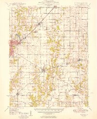
1949 Map of Hillsboro
USGS Topo · Published 1949About this map
Hillsboro serves as the focal point of this Montgomery County landscape, where the confluence of several railroads shaped the mid-century economy. The New York Central and the New York Chicago and St Louis lines bisect the terrain, connecting industrial nodes like Schram City and Coffeen. Local infrastructure is visible in the presence of the Big Four Reservoir and the nearby Airport, while rural life is anchored by dozens of neighborhood schoolhouses and churches. Family history researchers will find a dense network of burial sites, including the Cress Hill Cem, Hopewell Cem, and Donnellson Cem. The natural drainage is defined by the Middle Fork Shoal Creek and its many tributaries, which provided the necessary water resources for the scattered settlements and the County Farm near the hills of Bald Knob.
Find a feature on this map
90 named features on this map. Tap any name to fly to it.
Don’t see what you’re looking for? This feature index may not catch every label — zoom into the map to look around manually.
Map Details
Editions of this 1949 Hillsboro Map
2 editions found
Other maps of this area

1915 · Mount Olive
USGS Topo · 1:62,500

1923 · Raymond
USGS Topo · 1:62,500

1925 · Raymond
USGS Topo · 1:62,500

1932 · Greenville
USGS Topo · 1:62,500

1937 · New Douglas
USGS Topo · 1:48,000

1939 · Greenville
USGS Topo · 1:62,500

1943 · Greenville
USGS Topo · 1:62,500

1944 · New Douglas
USGS Topo · 1:62,500

1944 · Mount Olive
USGS Topo · 1:62,500

1944 · Ramsey
USGS Topo · 1:62,500