
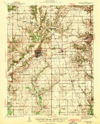
1943 Map of Greenville
USGS Topo · Published 1943About this map
Greenville serves as the focal point of this Bond County landscape, where the confluence of the Pennsylvania and Chicago Burlington and Quincy railroads once defined the local economy. Beyond the main settlement, a dense network of early 20th-century rural infrastructure is visible, including the CCC Camp and numerous district schools like Persimmon Grove Sch and Shady Grove Sch. The geography is deeply tied to the drainage of Shoal Creek and Beaver Creek, which influenced the placement of early post offices and hamlets. Genealogists will find a wealth of family-named landmarks and cemeteries, such as Jett Cem and Hastings Cem, alongside established rural congregations at Union Grove Ch and Mt Carmel Ch. The presence of the Wisetown Beaver Creek P O and smaller rail sidings at Ayers and Smithboro illustrates the transition from isolated frontier farmsteads to a connected agrarian region.
Find a feature on this map
93 named features on this map. Tap any name to fly to it.
Don’t see what you’re looking for? This feature index may not catch every label — zoom into the map to look around manually.
Map Details
Editions of this 1943 Greenville Map
2 editions found
Other maps of this area

1906 · Breese
USGS Topo · 1:62,500

1907 · Breese
USGS Topo · 1:62,500

1910 · Carlyle
USGS Topo · 1:62,500

1914 · Centralia
USGS Topo · 1:62,500

1915 · Mount Olive
USGS Topo · 1:62,500

1932 · Greenville
USGS Topo · 1:62,500

1935 · Centralia
USGS Topo · 1:62,500

1937 · New Douglas
USGS Topo · 1:48,000

1939 · Greenville
USGS Topo · 1:62,500

1944 · New Douglas
USGS Topo · 1:62,500