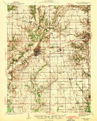
1943 Map of Greenville
USGS Topo · Published 1943About this map
Greenville serves as the central hub of this mid-century Bond County landscape, where the Pennsylvania RR and several regional roads converge. The settlement pattern reveals a high density of rural institutions, particularly one-room schoolhouses like Elm Point Sch and Rhea Sch that once served the surrounding farming townships. A notable wartime presence is marked by the CCC Camp located just south of the main town, reflecting the era's federal infrastructure and conservation projects.
Find a feature on this map
87 named features on this map. Tap any name to fly to it.
Don’t see what you’re looking for? This feature index may not catch every label — zoom into the map to look around manually.
Map Details
Editions of this 1943 Greenville Map
2 editions found
Other maps of this area

1906 · Breese
USGS Topo · 1:62,500

1907 · Breese
USGS Topo · 1:62,500

1910 · Carlyle
USGS Topo · 1:62,500

1914 · Centralia
USGS Topo · 1:62,500

1915 · Mount Olive
USGS Topo · 1:62,500

1932 · Greenville
USGS Topo · 1:62,500

1935 · Centralia
USGS Topo · 1:62,500

1937 · New Douglas
USGS Topo · 1:48,000

1939 · Greenville
USGS Topo · 1:62,500

1943 · Greenville
USGS Topo · 1:62,500