1990s Maps of Witt, Illinois
Explore 2 historic maps of Witt from the 1990s. These maps offer a rare glimpse into what life looked like during the 1990s — showing old roads, neighborhoods, homes, and landmarks that have changed or disappeared over time.
Whether you're researching your family's past, planning a metal detecting trip, or studying how Witt's landscape evolved across the 1990s, these high-resolution maps are a powerful tool for exploring the history of this region.
- Focus on a specific era: All maps on this page are from the 1990s, giving you a focused view of this time period.
- See what’s changed: Compare century-old streets, trails, and buildings to today's modern landscape using overlays and satellite layers.
- Research with precision: Use these maps for genealogy, historical research, land use analysis, or educational projects.
- View, download, or print: Maps are fully viewable online in high resolution, and can be downloaded or printed for your own records.
Start exploring Witt's history through authentic maps from the 1990s. This is your window into the past.
Witt, IL maps
(2)- 1998 Map of Nokomis, 2002 Print
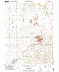 1998 Nokomis2002 Print · USGSThe Montgomery County prairie around the turn of the millennium shows a landscape defined by small-town grids and industrial sites. Family historians can trace local roots through landmarks like Oak Grove Cem, St Paul Sch, and the quiet settlements of Coalton and Witt.
 - 1998 Map of Bald Knob, 2002 Print
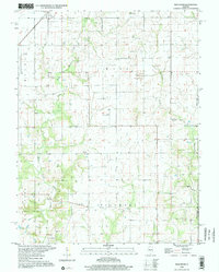 1998 Bald Knob2002 Print · USGSThe agricultural heart of Montgomery and Fayette counties is captured in the late twentieth century, showing the small-town life around Witt. Genealogists can trace family roots through sites like Armentrout Cemetery, Woodside Church, and the distinctive Bald Knob summit.
End of results
Showing maps 1-2 of 2
Top cities near Witt
- Taylorville historical maps
- Hillsboro historical maps
- Nokomis historical maps
- Morrisonville historical maps
- Raymond historical maps
- Coffeen historical maps
See more
Frequently asked questions
- What are the different types of historical maps available for Witt?
- What is the oldest map of Witt?
- Where can I purchase historical maps of Witt for my home or office?
- Where can I download high-res historical maps of Witt?
- Are there historical topographic maps available for Witt?
- Is there historical aerial imagery available for Witt?
- Where are historical maps of Witt sourced from?