1900s (20th Century) Maps of Franklin, Illinois
Explore 8 historic maps of Franklin from the 1900s (20th Century). These maps offer a rare glimpse into what life looked like during the 1900s — showing old roads, neighborhoods, homes, and landmarks that have changed or disappeared over time.
Whether you're researching your family's past, planning a metal detecting trip, or studying how Franklin's landscape evolved across the 1900s, these high-resolution maps are a powerful tool for exploring the history of this region.
- Focus on a specific era: All maps on this page are from the 1900s, giving you a focused view of this time period.
- See what’s changed: Compare century-old streets, trails, and buildings to today's modern landscape using overlays and satellite layers.
- Research with precision: Use these maps for genealogy, historical research, land use analysis, or educational projects.
- View, download, or print: Maps are fully viewable online in high resolution, and can be downloaded or printed for your own records.
Start exploring Franklin's history through authentic maps from the 1900s. This is your window into the past.
Franklin, IL maps
(8)- 1932 Map of Jacksonville, 1965 Print
 1932 Jacksonville1965 Print · USGSCentral Illinois farm country and the growing hub of Jacksonville are captured in the early 1930s before modern highway expansion. Researchers can trace dozens of country schools and churches, including Douglas Institute, Whitlock Cem, and the rural post at Pisgah.2 unique versions available
 - 1937 Map of Jacksonville
 1937 Jacksonville1937 Print · USGSMid-century Morgan County thrives as a rail and education hub just before the pre-war era. Researchers can trace ancestral roots at Whitlock Cem or locate defunct schools like Sulphur Springs Sch and Prairie College Sch.2 unique versions available
 - 1948 Map of Quincy
 1948 Quincy1948 Print · USGSThe Mississippi and Illinois River valleys are captured at a post-war crossroads as rail and river travel met the expanding highway system. Genealogists can trace family settlements from Quincy to Hannibal and smaller towns like Vandalia and Jerseyville.2 unique versions available
 - 1956 Map of Quincy, 1967 Print
 1956 Quincy1967 Print · USGSThe river and rail corridors of the Illinois-Missouri border are documented here during the mid-1950s. Researchers can trace historic river landings and regional transit hubs from Quincy and Hannibal to smaller settlements like Meredosia and Roodhouse.3 unique versions available
 - 1983 Map of Franklin
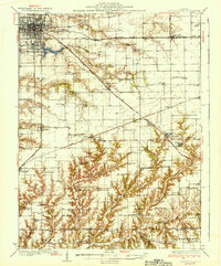
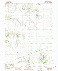
 1983 Franklin1983 Print · USGSMorgan and Macoupin counties come alive in the early eighties, centered on the rail-linked town of Franklin. Genealogists can trace rural roots at Harts Prairie Ch, Providence Cem, and the small settlement of Centerville.
 - 1983 Map of Alexander
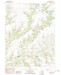
 1983 Alexander1983 Print · USGSMorgan County farmland and rural rail junctions are captured in the early 1980s during a period of steady agricultural use. Genealogists and local historians can locate Pisgah Cem, Sacred Heart Cem, and the small settlements of Alexander and Orleans.
 - 1985 Map of Meredosia, 1988 Print
 1985 Meredosia1988 Print · USGSWest Central Illinois in the mid-eighties was a landscape of deep-rooted river towns and historic educational institutions. Genealogists and historians can trace family ties through Diamond Grove Cem, locate MacMurray College in Jacksonville, or study the river engineering at La Grange Lock and Dam.
 - 1990 Map of Meredosia
 1990 Meredosia1990 Print · USGSThe Illinois River valley and its surrounding farm towns are captured here in the 1990s. Trace the intricate rail lines of the Norfolk Southern Railway and find local landmarks like Diamond Grove Cem or the Meredosia National Wildlife Refuge.
End of results
Showing maps 1-8 of 8
Top cities near Franklin
- Jacksonville historical maps
- South Jacksonville historical maps
- New Berlin historical maps
- Waverly historical maps
- Loami historical maps
- Palmyra historical maps
See more
Frequently asked questions
- What are the different types of historical maps available for Franklin?
- What is the oldest map of Franklin?
- Where can I purchase historical maps of Franklin for my home or office?
- Where can I download high-res historical maps of Franklin?
- Are there historical topographic maps available for Franklin?
- Is there historical aerial imagery available for Franklin?
- Where are historical maps of Franklin sourced from?