
1932 Map of Jacksonville
USGS Topo · Published 1965About this map
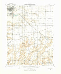
Jacksonville serves as the bustling regional hub of Morgan County on this 1930s-era landscape, where the Wabash and Alton railroad lines intersect. The map reveals an exceptionally dense network of rural education, documenting dozens of named schoolhouses like Brush College and Douglas Institute that served local farmsteads before district consolidation. Beyond the city grid of South Jacksonville, the terrain transitions into the creek-carved bottomlands of the Mauvaisterre and Apple Creek systems. These drainages are dotted with small social centers such as Nortonville and Pisgah, often anchored by local congregations like Salem Church or Providence Church. For genealogists, the map is a detailed record of local family history, preserving the locations of the Whitlock Cem and Spencer Cem alongside isolated rural landmarks such as Sulphur Springs School and Science Hill School.
Find a feature on this map
78 named features on this map. Tap any name to fly to it.
Don’t see what you’re looking for? This feature index may not catch every label — zoom into the map to look around manually.
Map Details
Editions of this 1932 Jacksonville Map
2 editions found
Other maps of this area

1909 · Tallula
USGS Topo · 1:62,500

1923 · Carlinville
USGS Topo · 1:48,000

1924 · Winchester
USGS Topo · 1:48,000

1924 · Waverly
USGS Topo · 1:62,500

1924 · Roodhouse
USGS Topo · 1:62,500

1925 · Carlinville
USGS Topo · 1:62,500

1926 · Winchester
USGS Topo · 1:62,500

1926 · Waverly
USGS Topo · 1:62,500

1926 · Roodhouse
USGS Topo · 1:62,500

1929 · Arenzville
USGS Topo · 1:62,500