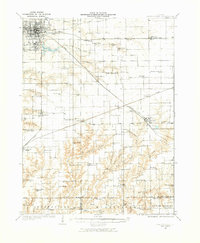
1932 Map of Jacksonville
USGS Topo · Published 1973About this map
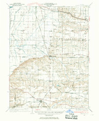
Jacksonville serves as the primary hub of this Central Illinois region during the early 1930s, showing a well-developed grid of streets and key institutions like the Douglas Institute. The landscape is defined by the drainage basins of Mauvaise Terre Creek and Apple Creek, where a dense network of country schools and churches supported a robust rural population. Notable landmarks include the Routt Sch and Prairie College Sch, alongside numerous family-linked burial grounds such as Whitlock Cem and Bull Cem. The transportation infrastructure is anchored by three major rail lines—the Wabash, the Alton, and the Chicago Burlington and Quincy—which connected smaller settlements like Pisgah, Woodson, and Franklin to the wider markets. This era of surveying captures the transition of the Illinois prairie into a highly organized agricultural and institutional landscape.
Find a feature on this map
96 named features on this map. Tap any name to fly to it.
Don’t see what you’re looking for? This feature index may not catch every label — zoom into the map to look around manually.
Map Details
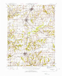
Editions of this 1932 Jacksonville Map
2 editions found

Other maps of this area

1909 · Tallula
USGS Topo · 1:62,500

1923 · Carlinville
USGS Topo · 1:48,000

1924 · Winchester
USGS Topo · 1:48,000

1924 · Waverly
USGS Topo · 1:62,500
1924 · Roodhouse
USGS Topo · 1:62,500
1925 · Carlinville
USGS Topo · 1:62,500

1926 · Winchester
USGS Topo · 1:62,500

1926 · Waverly
USGS Topo · 1:62,500
1926 · Roodhouse
USGS Topo · 1:62,500
1929 · Arenzville
USGS Topo · 1:62,500