1980s Maps of Murrayville, Illinois
Explore 3 historic maps of Murrayville from the 1980s. These maps offer a rare glimpse into what life looked like during the 1980s — showing old roads, neighborhoods, homes, and landmarks that have changed or disappeared over time.
Whether you're researching your family's past, planning a metal detecting trip, or studying how Murrayville's landscape evolved across the 1980s, these high-resolution maps are a powerful tool for exploring the history of this region.
- Focus on a specific era: All maps on this page are from the 1980s, giving you a focused view of this time period.
- See what’s changed: Compare century-old streets, trails, and buildings to today's modern landscape using overlays and satellite layers.
- Research with precision: Use these maps for genealogy, historical research, land use analysis, or educational projects.
- View, download, or print: Maps are fully viewable online in high resolution, and can be downloaded or printed for your own records.
Start exploring Murrayville's history through authentic maps from the 1980s. This is your window into the past.
Murrayville, IL maps
(3)- 1983 Map of Manchester
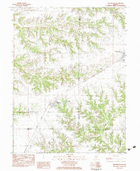 1983 Manchester1983 Print · USGSManchester and Murrayville are captured here in the early eighties as agricultural and rail hubs. Trace the path of the Illinois Central Gulf railroad or locate rural landmarks like East Union Church and Bethel Cemetery.
 - 1983 Map of Nortonville
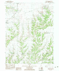 1983 Nortonville1983 Print · USGSAgricultural life in central Illinois during the late 1970s and early 80s is defined here by its rail lines and creek valleys. Family researchers can trace deep local roots at St Bartholomew Cem, Youngblood Ch, and the town of Nortonville.
 - 1985 Map of Meredosia, 1988 Print
 1985 Meredosia1988 Print · USGSWest Central Illinois in the mid-eighties was a landscape of deep-rooted river towns and historic educational institutions. Genealogists and historians can trace family ties through Diamond Grove Cem, locate MacMurray College in Jacksonville, or study the river engineering at La Grange Lock and Dam.
End of results
Showing maps 1-3 of 3
Top cities near Murrayville
- Jacksonville historical maps
- South Jacksonville historical maps
- White Hall historical maps
- Winchester historical maps
- Roodhouse historical maps
- Chapin historical maps
See more
Frequently asked questions
- What are the different types of historical maps available for Murrayville?
- What is the oldest map of Murrayville?
- Where can I purchase historical maps of Murrayville for my home or office?
- Where can I download high-res historical maps of Murrayville?
- Are there historical topographic maps available for Murrayville?
- Is there historical aerial imagery available for Murrayville?
- Where are historical maps of Murrayville sourced from?