1990s Maps of Peoria, Illinois
Explore 5 historic maps of Peoria from the 1990s. These maps offer a rare glimpse into what life looked like during the 1990s — showing old roads, neighborhoods, homes, and landmarks that have changed or disappeared over time.
Whether you're researching your family's past, planning a metal detecting trip, or studying how Peoria's landscape evolved across the 1990s, these high-resolution maps are a powerful tool for exploring the history of this region.
- Focus on a specific era: All maps on this page are from the 1990s, giving you a focused view of this time period.
- See what’s changed: Compare century-old streets, trails, and buildings to today's modern landscape using overlays and satellite layers.
- Research with precision: Use these maps for genealogy, historical research, land use analysis, or educational projects.
- View, download, or print: Maps are fully viewable online in high resolution, and can be downloaded or printed for your own records.
Start exploring Peoria's history through authentic maps from the 1990s. This is your window into the past.
Peoria, IL maps
(5)- 1990 Map of Peoria
 1990 Peoria1990 Print · USGSCentral Illinois at the start of the nineties reveals a landscape of industrial river towns and sprawling university campuses. Researchers can trace the legacy of major institutions like Chanute Air Force Base and the University of Illinois alongside regional landmarks such as Sand Ridge State Forest.
 - 1996 Map of Spring Bay, 1997 Print
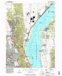 1996 Spring Bay1997 Print · USGSThe Illinois River valley north of Peoria comes into focus in the mid-1990s, showing a mix of industrial riverfront and wooded bluffs. Researchers can trace local landmarks like Mt Hawley Auxiliary Airport, Robinson Cem, and the community of Mossville.
 - 1996 Map of Peoria East, 1997 Print
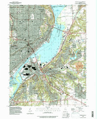 1996 Peoria East1997 Print · USGSThe Illinois River valley in the late twentieth century reveals a bustling metropolitan hub where industry and education meet on the water. Researchers can trace family roots through Bradley University, find old burials at Mooberry Cem, or locate landmarks like Fort Creve Coeur State Park.
 - 1996 Map of Peoria West, 1997 Print
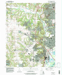 1996 Peoria West1997 Print · USGSGreater Peoria in the mid-1990s reveals a complex network of industrial rail, suburban expansion, and river infrastructure. Genealogists and local historians can trace family-named sites like Cameron Cem, schools such as Oak Grove West Sch, and the layout of Pottstown.
 - 1996 Map of Dunlap, 1997 Print
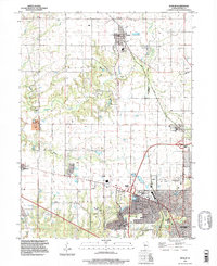 1996 Dunlap1997 Print · USGSCentral Illinois farmland meets suburban growth in the late twentieth century near Peoria. Researchers can trace local history through family-named landmarks like Dickson Cem and the route of the Rock Island Trail State Park.
End of results
Showing maps 1-5 of 5
Top cities near Peoria
- Pekin historical maps
- East Peoria historical maps
- Groveland historical maps
- Morton historical maps
- Washington historical maps
- Bartonville historical maps
See more
Top neighborhoods of Peoria
- Sankoty historical maps
- El Vista historical maps
- Keller historical maps
- Arbor District historical maps
- Roanoke-Randolph Street Historic District historical maps
- Armstrong-Ellis historical maps
See more
Frequently asked questions
- What are the different types of historical maps available for Peoria?
- What is the oldest map of Peoria?
- Where can I purchase historical maps of Peoria for my home or office?
- Where can I download high-res historical maps of Peoria?
- Are there historical topographic maps available for Peoria?
- Is there historical aerial imagery available for Peoria?
- Where are historical maps of Peoria sourced from?