1950s Maps of Pulaski County, Illinois
Explore 9 historic maps of Pulaski County from the 1950s. These maps offer a rare glimpse into what life looked like during the 1950s — showing old roads, neighborhoods, homes, and landmarks that have changed or disappeared over time.
Whether you're researching your family's past, planning a metal detecting trip, or studying how Pulaski County's landscape evolved across the 1950s, these high-resolution maps are a powerful tool for exploring the history of this region.
- Focus on a specific era: All maps on this page are from the 1950s, giving you a focused view of this time period.
- See what’s changed: Compare century-old streets, trails, and buildings to today's modern landscape using overlays and satellite layers.
- Research with precision: Use these maps for genealogy, historical research, land use analysis, or educational projects.
- View, download, or print: Maps are fully viewable online in high resolution, and can be downloaded or printed for your own records.
Start exploring Pulaski County's history through authentic maps from the 1950s. This is your window into the past.
Pulaski County, IL maps
(9)- 1950 Map of Paducah
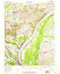
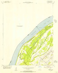
 1950 Paducah1950 Print · USGSThe confluence of the great midwestern rivers defines this mid-century landscape at the intersection of Illinois, Kentucky, and Missouri. Genealogists and historians can trace the rail-and-river economy through the hubs of Paducah, Cairo, and Metropolis or locate family roots near the Wildcat Hills.
 - 1953 Map of Cairo, 1959 Print
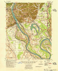
 1953 Cairo1959 Print · USGSThe confluence of the Ohio and Mississippi Rivers is captured here in the mid-1950s, showing a landscape defined by floodgates and rail lines. Researchers can trace the layout of Cairo, find family plots at Hazelwood Cem, or locate landmarks like the National Cemetery and Cairo Airport.3 unique versions available
 - 1954 Map of Paducah
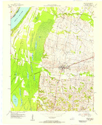
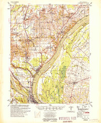
 1954 Paducah1954 Print · USGSSouthern Illinois and Western Kentucky intersect at the great river confluences during this mid-century era of rail and river industry. Genealogists and historians can trace family roots and commerce through river towns like Cairo, Metropolis, and Golconda, or along the tracks of the Illinois Central Railroad.2 unique versions available
 - 1954 Map of Barlow, 1955 Print
 1954 Barlow1955 Print · USGSBallard County and the banks of the Ohio River appear in the mid-fifties as a landscape of productive farms and intricate bottomland sloughs. Researchers can trace family history at Old Hazelwood Cem or explore the rail-era footprint of Barlow and the Illinois Central Railroad Grade.
 - 1954 Map of Cairo, 1955 Print
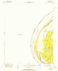 1954 Cairo1955 Print · USGSThe Kentucky side of the Ohio River in the mid-1950s reveals a landscape defined by the wetlands and sloughs of the BARLOW BOTTOMS. Genealogists and local historians can trace the paths of the GULF CENTRAL MOBILE AND OHIO RAILROAD near East Cairo and the unique topography of Twin Mounds.
 - 1954 Map of Bandana, 1955 Print
 1954 Bandana1955 Print · USGSThe riverfront and farming communities of Ballard County are captured here in the mid-fifties, just south of the Ohio River. Genealogists and historians can trace family locations near Bandana, the uniquely named Monkeys Eyebrow, and Herrin Cem.
 - 1954 Map of Olmsted, 1955 Print
 1954 Olmsted1955 Print · USGSThe Ohio River borderlands at the mid-century reveal a landscape of river navigation and bottomland farming. Genealogists and historians can trace the settlement of Oscar and its local landmarks like Oscar Ch, New Hope Ch, and Lock and Dam No 53.
 - 1955 Map of Thebes
 1955 Thebes1955 Print · USGSThe Illinois riverfront near the confluence of the Mississippi and Cache rivers shows a landscape of timber and rail in the mid-1950s. Genealogists and historians can trace family locations near Richwood Cem, the junction at Thebes, and remote rural schoolhouses like Owensby Sch.
 - 1955 Map of Cairo
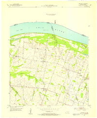
 1955 Cairo1955 Print · USGSThe confluence of the great rivers at the southern tip of Illinois is captured here in the mid-1950s. Trace the vital rail hubs of Cairo, explore the grounds of the National Cemetery, and locate vanished rural schools like America Sch and Bryan Sch.
End of results
Showing maps 1-9 of 9
Top cities of Pulaski County
- Mounds historical maps
- Ullin historical maps
- Mound City historical maps
- Karnak historical maps
- Olmsted historical maps
- Pulaski historical maps
See more
Frequently asked questions
- What are the different types of historical maps available for Pulaski County?
- What is the oldest map of Pulaski County?
- Where can I purchase historical maps of Pulaski County for my home or office?
- Where can I download high-res historical maps of Pulaski County?
- Are there historical topographic maps available for Pulaski County?
- Is there historical aerial imagery available for Pulaski County?
- Where are historical maps of Pulaski County sourced from?