1940s Maps of Pulaski County, Illinois
Explore 6 historic maps of Pulaski County from the 1940s. These maps offer a rare glimpse into what life looked like during the 1940s — showing old roads, neighborhoods, homes, and landmarks that have changed or disappeared over time.
Whether you're researching your family's past, planning a metal detecting trip, or studying how Pulaski County's landscape evolved across the 1940s, these high-resolution maps are a powerful tool for exploring the history of this region.
- Focus on a specific era: All maps on this page are from the 1940s, giving you a focused view of this time period.
- See what’s changed: Compare century-old streets, trails, and buildings to today's modern landscape using overlays and satellite layers.
- Research with precision: Use these maps for genealogy, historical research, land use analysis, or educational projects.
- View, download, or print: Maps are fully viewable online in high resolution, and can be downloaded or printed for your own records.
Start exploring Pulaski County's history through authentic maps from the 1940s. This is your window into the past.
Pulaski County, IL maps
(6)- 1942 Map of Vienna, 1958 Print
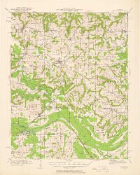 1942 Vienna1958 Print · USGSSouthern Illinois hill country and the Cache River lowlands are shown here during the early 1940s, highlighting a landscape of rail-connected towns and rural school districts. Researchers can trace family roots through numerous sites like Oliver Cemetery, Tall Tree School, and the Crossroads Store.2 unique versions available
 - 1947 Map of Jonesboro, 1954 Print
 1947 Jonesboro1954 Print · USGSSouthern Illinois in the late 1940s reveals a landscape defined by the Mississippi riverfront and the deep woods of the Shawnee National Forest. Researchers can trace early rural infrastructure through numerous sites like Egypt Mills, Dutch Mills, and the historic Kornthal Church.3 unique versions available
 - 1947 Map of Mill Creek, 1978 Print
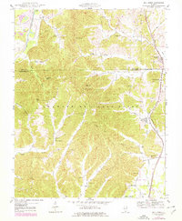 1947 Mill Creek1978 Print · USGSSouthern Illinois at the edge of the Shawnee Hills comes alive in this mid-century survey of the Union and Alexander County line. Genealogists can locate family burial sites like McClure Cem and Sims Cem or trace the old rail lines serving Mill Creek and Tamms.2 unique versions available
 - 1948 Map of Mill Creek
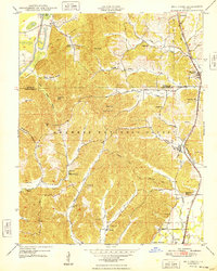 1948 Mill Creek1948 Print · USGSSouthern Illinois hill country comes alive in the late 1940s as the railroad connects the timber and creek valleys of the Shawnee National Forest. Genealogists and historians can trace family locations through McClure Cem, Hazelwood School, and the village of Elco.2 unique versions available
 - 1949 Map of Jonesboro
 1949 Jonesboro1949 Print · USGSSouthern Illinois and eastern Missouri meet along the river in the late 1940s, showing a landscape of fertile bottomlands and timbered ridges. Genealogists can locate family landmarks like Kornthal Church, Tripp Cem, and the Misenheimer School.
 - 1949 Map of Paducah
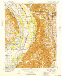
 1949 Paducah1949 Print · USGSThe confluence of the Ohio, Mississippi, Tennessee, and Cumberland rivers at the close of the 1940s reveals a region bound by water and rail. Researchers can trace historic river landings, timberlands in the Shawnee National Forest, and the coal-mining infrastructure around West Frankfort and Herrin.2 unique versions available
End of results
Showing maps 1-6 of 6
Top cities of Pulaski County
- Mounds historical maps
- Ullin historical maps
- Mound City historical maps
- Karnak historical maps
- Olmsted historical maps
- Pulaski historical maps
See more
Frequently asked questions
- What are the different types of historical maps available for Pulaski County?
- What is the oldest map of Pulaski County?
- Where can I purchase historical maps of Pulaski County for my home or office?
- Where can I download high-res historical maps of Pulaski County?
- Are there historical topographic maps available for Pulaski County?
- Is there historical aerial imagery available for Pulaski County?
- Where are historical maps of Pulaski County sourced from?