1970s Maps of Richland County, Illinois
Explore 6 historic maps of Richland County from the 1970s. These maps offer a rare glimpse into what life looked like during the 1970s — showing old roads, neighborhoods, homes, and landmarks that have changed or disappeared over time.
Whether you're researching your family's past, planning a metal detecting trip, or studying how Richland County's landscape evolved across the 1970s, these high-resolution maps are a powerful tool for exploring the history of this region.
- Focus on a specific era: All maps on this page are from the 1970s, giving you a focused view of this time period.
- See what’s changed: Compare century-old streets, trails, and buildings to today's modern landscape using overlays and satellite layers.
- Research with precision: Use these maps for genealogy, historical research, land use analysis, or educational projects.
- View, download, or print: Maps are fully viewable online in high resolution, and can be downloaded or printed for your own records.
Start exploring Richland County's history through authentic maps from the 1970s. This is your window into the past.
Richland County, IL maps
(6)- 1970 Map of Clay City, 1971 Print
 1970 Clay City1971 Print · USGSClay County at the dawn of the seventies is defined here by the intersection of river transport and petroleum industry. Genealogists can trace family landmarks like Hanna Cem and South Freedom Ch alongside the busy Baltimore and Ohio rail line.2 unique versions available
 - 1970 Map of Enterprise, 1971 Print
 1970 Enterprise1971 Print · USGSWayne and Clay counties are shown here in the 1970s, a period when the local economy was shaped by the Clay City Oil Field and river bottom farming. Researchers can locate numerous family burial sites and rural landmarks like Enterprise, Laird Cem, and Patterson Ch.
 - 1971 Map of Mount Erie, 1973 Print
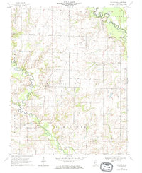
 1971 Mount Erie1973 Print · USGSWayne County settlement centers on the high ground near Mount Erie in the early 1970s, while the Little Wabash River meanders through the bottomlands. Researchers can trace rural lineages through numerous local sites like Wynoose Cem, Forest Ridge Ch, and the crossroads at Bennington.2 unique versions available
 - 1971 Map of West Salem, 1973 Print
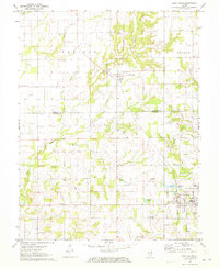 1971 West Salem1973 Print · USGSSoutheastern Illinois reveals its rural character and energy history in the early seventies as the Edwards and Richland County line meets. Genealogists and historians can trace numerous family burial sites and country churches, including Bethel Cemetery, Marion Church, and the Moravian Cemetery.
 - 1971 Map of Olney, 1973 Print
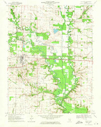
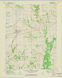
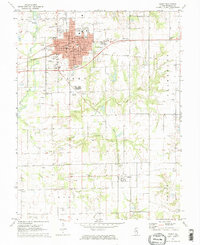 1971 Olney1973 Print · USGSRichland County at the start of the 1970s reveals a landscape shaped by the rail junction at Olney and active petroleum extraction. Genealogists and historians can trace family plots at Haven Hill Cem, locate the Richland Sch, or follow the Illinois Central line to Calhoun.2 unique versions available
 - 1971 Map of Noble, 1973 Print
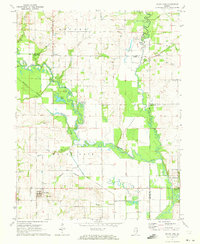
 1971 Noble1973 Print · USGSRichland County at the start of the 1970s is a landscape of rural crossroads and active energy extraction. Genealogists and historians can trace family locations near Noble using landmarks like Decker Cem, Antioch Ch, and the Noble Oil Field.2 unique versions available
End of results
Showing maps 1-6 of 6
Top cities of Richland County
- Olney historical maps
- Noble historical maps
- Parkersburg historical maps
- Calhoun historical maps
- Claremont historical maps
Frequently asked questions
- What are the different types of historical maps available for Richland County?
- What is the oldest map of Richland County?
- Where can I purchase historical maps of Richland County for my home or office?
- Where can I download high-res historical maps of Richland County?
- Are there historical topographic maps available for Richland County?
- Is there historical aerial imagery available for Richland County?
- Where are historical maps of Richland County sourced from?