1960s Maps of Richland County, Illinois
Explore 4 historic maps of Richland County from the 1960s. These maps offer a rare glimpse into what life looked like during the 1960s — showing old roads, neighborhoods, homes, and landmarks that have changed or disappeared over time.
Whether you're researching your family's past, planning a metal detecting trip, or studying how Richland County's landscape evolved across the 1960s, these high-resolution maps are a powerful tool for exploring the history of this region.
- Focus on a specific era: All maps on this page are from the 1960s, giving you a focused view of this time period.
- See what’s changed: Compare century-old streets, trails, and buildings to today's modern landscape using overlays and satellite layers.
- Research with precision: Use these maps for genealogy, historical research, land use analysis, or educational projects.
- View, download, or print: Maps are fully viewable online in high resolution, and can be downloaded or printed for your own records.
Start exploring Richland County's history through authentic maps from the 1960s. This is your window into the past.
Richland County, IL maps
(4)- 1962 Map of Belleville
 1962 Belleville1962 Print · USGSSouthern Illinois in the late fifties reveals a landscape of industrial growth and ancient landmarks before the full expansion of the interstate system. Genealogists can trace family names and rural post offices near Centralia, Salem, and the historic Monks Mound.
 - 1968 Map of Berryville, 1969 Print
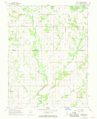 1968 Berryville1969 Print · USGSSoutheast Illinois at the end of the sixties reveals a rural landscape where county lines meet along the Old Indian Treaty Boundary. Genealogists can locate several family landmarks and burial sites like Welser Cem, Pinhook Cem, and Pleasant Grove Ch.
 - 1968 Map of Landes, 1970 Print
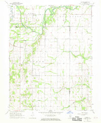 1968 Landes1970 Print · USGSRichland and Jasper counties in the late sixties remain a patchwork of small townships and rural parishes. Family historians can trace local roots through numerous country landmarks like South Bend Cem, St Joseph Sch, and the Amity settlement.
 - 1968 Map of Claremont, 1970 Print
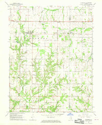 1968 Claremont1970 Print · USGSRichland and Lawrence counties appear here in the late sixties, centered on the railroad town of Claremont. Researchers can trace old family burial sites like Dutch Flat Cem and Brian Cem or locate rural landmarks like Otterbein Ch.
End of results
Showing maps 1-4 of 4
Top cities of Richland County
- Olney historical maps
- Noble historical maps
- Parkersburg historical maps
- Calhoun historical maps
- Claremont historical maps
Frequently asked questions
- What are the different types of historical maps available for Richland County?
- What is the oldest map of Richland County?
- Where can I purchase historical maps of Richland County for my home or office?
- Where can I download high-res historical maps of Richland County?
- Are there historical topographic maps available for Richland County?
- Is there historical aerial imagery available for Richland County?
- Where are historical maps of Richland County sourced from?