1950s Maps of Saint Clair County, Illinois
Explore 24 historic maps of Saint Clair County from the 1950s. These maps offer a rare glimpse into what life looked like during the 1950s — showing old roads, neighborhoods, homes, and landmarks that have changed or disappeared over time.
Whether you're researching your family's past, planning a metal detecting trip, or studying how Saint Clair County's landscape evolved across the 1950s, these high-resolution maps are a powerful tool for exploring the history of this region.
- Focus on a specific era: All maps on this page are from the 1950s, giving you a focused view of this time period.
- See what’s changed: Compare century-old streets, trails, and buildings to today's modern landscape using overlays and satellite layers.
- Research with precision: Use these maps for genealogy, historical research, land use analysis, or educational projects.
- View, download, or print: Maps are fully viewable online in high resolution, and can be downloaded or printed for your own records.
Start exploring Saint Clair County's history through authentic maps from the 1950s. This is your window into the past.
Saint Clair County, IL maps
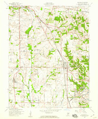
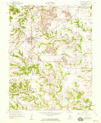
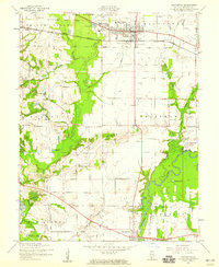
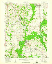
(24)- 1951 Map of Columbia
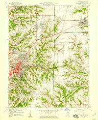
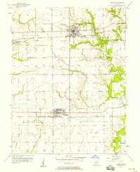
 1951 Columbia1951 Print · USGSMonroe and St. Clair counties appear here in the early fifties as the region balanced its agricultural roots with growing rail and oil interests. Researchers can find numerous family landmarks and rural institutions, from Shoemaker Cem and Lark Cem to the New Hanover Station.
 - 1954 Map of Freeburg, 1958 Print
 1954 Freeburg1958 Print · USGSSettled farmland and active coal extraction define this part of St. Clair County in the mid-1950s. Genealogists can trace family names at Walnut Hill Cem or St Josephs Cem, while historians can locate the old Turkey Hill Sch and the Strip Mine works.3 unique versions available
 - 1954 Map of Granite City, 1958 Print
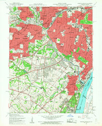
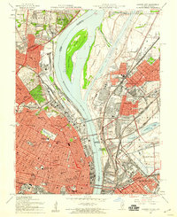 1954 Granite City1958 Print · USGSThe mid-century riverfront industrial landscape comes alive here where Missouri and Illinois meet at the Mississippi. Researchers can trace historic neighborhoods and landmarks from Busch Stadium to the sprawling Calvary Cemetery and the Chain of Rocks Canal.6 unique versions available
 - 1954 Map of Lebanon, 1959 Print
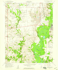
 1954 Lebanon1959 Print · USGSMid-century St. Clair County shows a landscape of historic granges and transitioning rural schools near the growing Scott Air Force Base. Genealogists can trace family plots at Bridges Cem or College Hill Cem and locate vanished landmarks like the Choctaw Sch.4 unique versions available
 - 1954 Map of New Athens West, 1959 Print
 1954 New Athens West1959 Print · USGSThe Kaskaskia River and its intricate backwaters define this corner of St. Clair and Monroe counties in the mid-1950s. Genealogists and historians can trace the foundations of local life through the many country schools and cemeteries, such as McQuillan Sch, Brick Cem, and the village of Hecker.4 unique versions available
 - 1954 Map of Collinsville, 1959 Print
 1954 Collinsville1959 Print · USGSMid-century Madison County reveals an era of thriving rail junctions and local neighborhood schools. Genealogists and local historians can trace family locations through landmarks like Finland Cem, Troy Crossing, and Lanham Sch.4 unique versions available
 - 1954 Map of French Village, 1959 Print
 1954 French Village1959 Print · USGSSt. Clair County transitions from the industrial floodplain to the bluffs of Belleville and Signal Hill during the mid-fifties. Researchers can trace vanished rural landmarks like Twiss Hill Sch, the early grounds of St Henry College, and the sprawling landscape of Grand Marais State Park.5 unique versions available
 - 1954 Map of St. Jacob, 1959 Print
 1954 St. Jacob1959 Print · USGSMid-century Madison County is captured here at a time when the village of St Jacob remained a central hub for the surrounding township farms. Researchers can locate numerous family burial sites like Anderson Cem and Smart Cem or trace the geography around Emerald Mound.4 unique versions available
 - 1954 Map of Webster Groves, 1959 Print
 1954 Webster Groves1959 Print · USGSMid-century St. Louis and Webster Groves appear here during a period of rapid suburban maturation and institutional development. Genealogists can trace family sites near Jefferson Barracks, Resurrection Cemetery, and Luxemburg.5 unique versions available
 - 1954 Map of Millstadt, 1959 Print
 1954 Millstadt1959 Print · USGSSt. Clair County in the mid-fifties exhibits a landscape of rural schoolhouses and active coal extraction. Researchers can trace ancestral locations at Mt Evergreen Cem, find old rural schools like Saxtown Sch, and locate the hamlets of Floraville and Bohleysville.3 unique versions available
 - 1954 Map of Paderborn, 1959 Print
 1954 Paderborn1959 Print · USGSSt. Clair and Monroe counties are captured here in the mid-1950s, showing a landscape of family farms and small rural settlements. Genealogists can locate St Michaels Cem, trace the Gulf Mobile and Ohio rail line, or find local landmarks like Floraville and Rockhouse Sch.3 unique versions available
 - 1954 Map of Cahokia, 1959 Print
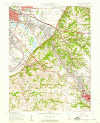
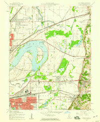
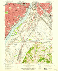 1954 Cahokia1959 Print · USGSMid-century St. Louis and East St. Louis are documented here at a peak of rail and river industry along the Mississippi River. Genealogists and historians can trace local landmarks from Old Cathedral and Holy Family Cem to the early aviation history of Parks Metropolitan Airport.5 unique versions available
 - 1954 Map of O'Fallon, 1959 Print
 1954 O'Fallon1959 Print · USGSMid-century St. Clair County thrives as an industrial and rail hub connecting Belleville and O'Fallon. Researchers can trace the legacy of the St Louis and O'Fallon Mine or locate family sites at Oak Hill Cem and Milburn Sch.4 unique versions available
 - 1954 Map of Mascoutah, 1959 Print
 1954 Mascoutah1959 Print · USGSSt. Clair County in the 1950s shows a transition from rural crossroads to growing rail towns. Genealogists can trace family names at Schneblin Cem and Knobeloch Cem, or locate long-closed schools like Jefferson Sch.4 unique versions available
 - 1954 Map of Monks Mound, 1959 Print
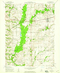
 1954 Monks Mound1959 Print · USGSThe Madison County bottomlands in the mid-1950s show a fascinating landscape of prehistoric earthworks and modern rail yards. Genealogists and historians can trace family-named schools and sites like Bullfrog Station Sch, Moellenbrocks, and the massive Monks Mound.5 unique versions available
 - 1954 Map of New Athens East, 1959 Print
 1954 New Athens East1959 Print · USGSSt. Clair County in the mid-1950s reveals a landscape where the river economy meets the emerging industrial footprint of strip mining and oil. Genealogists can locate family landmarks like St Agatha Cem and Dutch Hill Cem, or trace the railroad through Lenzburg.4 unique versions available
 - 1954 Map of Columbia, 1959 Print
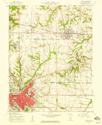
 1954 Columbia1959 Print · USGSThe bluffs of Monroe and St. Clair counties come alive in this mid-century survey, showing the transition from river bottoms to upland farms. Genealogists can trace family names at Immaculate Conception Ch or locate schools like Metter Sch and Sand Bank Sch.
 - 1954 Map of New Athens, 1960 Print
 1954 New Athens1960 Print · USGSSt. Clair County in the mid-fifties is captured here along the bends of the Kaskaskia River and its tributary rail lines. Genealogists can trace family names at Sturm Cem, Oak Ridge Cem, and rural schoolhouses like Five Points Sch.
 - 1955 Map of Waterloo, 1960 Print
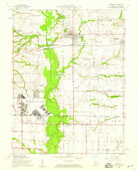
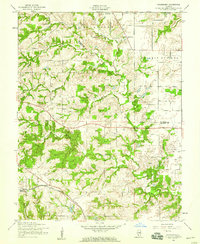
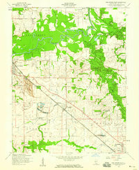
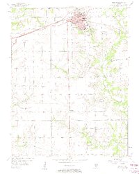
 1955 Waterloo1960 Print · USGSMonroe and St. Clair counties appear here in the mid-1950s as a thriving landscape of rural schools and rail-side villages. Researchers can trace family sites like St Augustine Cem or locate vanished landmarks such as Saxtown Sch and the Experimental Underground Line.
 - 1955 Map of Columbia, 1969 Print
 1955 Columbia1969 Print · USGSColumbia and the St. Clair and Monroe County line are shown here in the mid-fifties, just as suburban growth began to meet rural tradition. Researchers can trace rail history at Millstadt Junction or locate local landmarks like Sand Bank Sch and the Immaculate Conception Ch.3 unique versions available
 - 1957 Map of Highland, 1958 Print
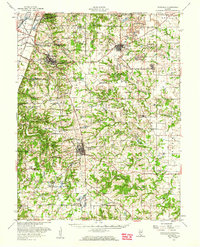
 1957 Highland1958 Print · USGSHighland and the surrounding Madison County townships are captured here in the mid-1950s as a thriving rail-side community. Researchers can trace family history through local landmarks like St Joseph Cemetery, Sugar Creek Church, and the rural enclave of St Morgan.3 unique versions available
 - 1957 Map of Venedy, 1958 Print
 1957 Venedy1958 Print · USGSSouthern Illinois at the peak of the post-war era shows a landscape defined by the winding Kaskaskia River and the busy Louisville and Nashville railroad. Genealogists can trace the rural communities of Venedy and Johannishurg, or locate family landmarks like the Miller Cem and several oxbow lakes.2 unique versions available
 - 1957 Map of Trenton, 1958 Print
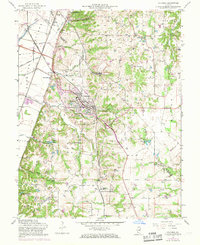
 1957 Trenton1958 Print · USGSThe border of St. Clair and Clinton counties was a hub of mid-century rail activity, centered on the growing communities of Trenton and New Baden. Genealogists and local historians can trace family plots at Harpstrite Cem or locate industrial sites like Knaus Quarry.2 unique versions available
 - 1958 Map of Belleville, 1973 Print
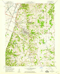
 1958 Belleville1973 Print · USGSSouthern Illinois during the mid-twentieth century reveals a landscape of industrial growth and massive new reservoirs. Genealogists and historians can trace the paths of the Illinois Central RR through towns like Centralia or locate landmarks such as Emerald Mound and the Looking Glass Prairie.3 unique versions available
End of results
Showing maps 1-24 of 24
Top cities of Saint Clair County
- Belleville historical maps
- O'Fallon historical maps
- East St. Louis historical maps
- Fairview Heights historical maps
- Swansea historical maps
- Shiloh historical maps
See more
Frequently asked questions
- What are the different types of historical maps available for Saint Clair County?
- What is the oldest map of Saint Clair County?
- Where can I purchase historical maps of Saint Clair County for my home or office?
- Where can I download high-res historical maps of Saint Clair County?
- Are there historical topographic maps available for Saint Clair County?
- Is there historical aerial imagery available for Saint Clair County?
- Where are historical maps of Saint Clair County sourced from?