Old Maps of Saint Clair County, Illinois for Metal Detecting
Plan your next treasure hunt with 201 historic maps of Saint Clair County. Find old homesites, ghost towns, trails, and gathering spots that may be lost to time — perfect for identifying promising metal detecting locations.
- Locate forgotten sites: Uncover places like long-lost settlements, abandoned rail lines, or gathering spots.
- Plan better hunts: Use map overlays combined with LiDAR or satellite views to narrow in on historically rich areas.
- Made for detectorists: Thousands of hobbyists use these maps to discover relics, coins, and hidden history.
Use these historic maps to boost your research and find new opportunities beneath the surface of Saint Clair County.
Saint Clair County, IL maps
(201)- 1888 Map of St. Louis
 1888 St. Louis1888 Print · USGSThe Illinois bottomlands across from St. Louis come alive in the late nineteenth century as a massive railroad hub emerging from the river wetlands. Researchers can trace early rail junctions and settlements like French Village, the ancient Monks Mound, and the industrial waterfronts of Brooklyn and East St Louis.
 - 1906 Map of Breese, 1958 Print
 1906 Breese1958 Print · USGSThe Illinois prairie east of St. Louis is shown here at the turn of the century, when rail lines and rural school districts formed the backbone of local life. Genealogy researchers can locate dozens of country schools like Linden School and Ruth School near established towns like Breese and Germantown.
 - 1907 Map of Breese
 1907 Breese1907 Print · USGSClinton and St. Clair counties were a bustling network of rail-towns and rural school districts at the turn of the century. Researchers can trace ancestral property near dozens of family-named landmarks like Richter School, McKee School, or the small village of Damiansville.2 unique versions available
 - 1907 Map of Belleville
 1907 Belleville1907 Print · USGSSouthwestern Illinois is seen at a height of rail-driven expansion in the early twentieth century. Trace genealogy and land history in Belleville, O'Fallon, and Summerfield along the Vandalia System and other regional lines.3 unique versions available
 - 1910 Map of Okawville
 1910 Okawville1910 Print · USGSEastern St. Clair and Washington counties appear here in the early 1900s, where the winding river bottomlands met the expanding railroad. Local historians can trace the development of Okawville along the Louisville & Nashville RR or find rural landmarks like Stone Church and Woodland School.2 unique versions available
 - 1910 Map of Waterloo, 1956 Print
 1910 Waterloo1956 Print · USGSMonroe and St. Clair counties are shown in detail during the early twentieth century, highlighting a landscape of rail-dependent prairie towns. Family historians can trace rural schools and churches like Oakdale School or Zion Church, and locate early stops on the Mobile and Ohio RR.
 - 1912 Map of New Athens
 1912 New Athens1912 Print · USGSThe St. Clair County prairies in the early nineteen-hundreds were a bustling corridor of river commerce and rail expansion. Genealogists and historians can locate vanished landmarks like Lementon, dozens of country schools, and the Kaskaskia River oxbows.2 unique versions available
 - 1912 Map of Baldwin, 1967 Print
 1912 Baldwin1967 Print · USGSRandolph and St. Clair counties come alive in this early twentieth-century survey of the Kaskaskia River valley. Genealogists can trace family footprints across dozens of local school sites, including Charter Oak School, Stringtown School, and the rural community of Schuline.
 - 1913 Map of Waterloo
 1913 Waterloo1913 Print · USGSMonroe and St. Clair counties are shown just after the first decade of the twentieth century as the region’s rural economy matured. Genealogists can trace family footprints through dozens of rural landmarks like Diamond Joe Mine, Palmer Cem, and the Mobile and Ohio RR.3 unique versions available
 - 1914 Map of Baldwin
 1914 Baldwin1914 Print · USGSSouthern Illinois farm country and the meandering Kaskaskia River define this 1910s landscape. Genealogists can locate nearly thirty named schoolhouses, including Hiawassie School and Risdon School, alongside the early routes of the Illinois Southern railroad.2 unique versions available
 - 1914 Map of Coulterville, 1965 Print
 1914 Coulterville1965 Print · USGSSouthern Illinois during the height of the steam era reveals a landscape of thriving rail hubs and rural school districts. Genealogists and local historians can trace the foundations of Sparta, Coulterville, and Steeleville alongside dozens of named country schools like Brick School and Temple School.
 - 1917 Map of Coulterville
 1917 Coulterville1917 Print · USGSSouthern Illinois during the early twentieth century was defined by its coal-belt junctions and a dense grid of rural schoolhouses. Genealogists and historians can trace family locations near landmarks like Lost Prairie School, the Illinois Central rail lines, and the growing town of Sparta.3 unique versions available
 - 1931 Map of French Village, 1954 Print
 1931 French Village1954 Print · USGSSt. Clair County's industrial and residential corridors are frozen in time during the early thirties, showing the dense rail networks and coal mining operations of the era. Genealogists can locate family landmarks like Twiss Hill Sch, the Booker T Washington Cemetery, and Gundlach Mines.
 - 1933 Map of Granite City
 1933 Granite City1933 Print · USGSThe riverfront and urban neighborhoods of St. Louis thrive during the early thirties as a hub of rail and river commerce. Genealogists and historians can trace family roots through numerous local parishes like St Joseph Ch and the vast Calvary Cemetery.2 unique versions available
 - 1933 Map of Jefferson Barracks
 1933 Jefferson Barracks1933 Print · USGSSouth St. Louis County and the riverfront during the mid-thirties reveal a landscape of expanding suburbs and deep military roots. Genealogists and historians can trace family plots in National Cem or locate the early centers of Luxemburg and Affton PO Grevois Sta.
 - 1933 Map of Cahokia
 1933 Cahokia1933 Print · USGSThe riverfront neighborhoods of south St. Louis are captured in detail during the early 1930s, showing a bustling landscape of schools and industry. Genealogists can trace family locations near Carondelet, St Anthony Ch, or the Mo Pac Hospital.
 - 1934 Map of Cahokia
 1934 Cahokia1934 Print · USGSThe industrial corridor and riverfront of St. Clair County are captured here in the mid-1930s as heavy rail and river commerce defined the landscape. Genealogists and historians can trace family-named schools and early settlements like Dupo, Lark Cem, and Falling Spring.2 unique versions available
 - 1935 Map of Lebanon
 1935 Lebanon1935 Print · USGSSt. Clair County is shown in the mid-1930s as a mix of rural prairie and emerging military aviation. Researchers can trace the early footprint of Scott Field and find community landmarks like Grassland Sch or the Mooring Mast.2 unique versions available
 - 1935 Map of French Village
 1935 French Village1935 Print · USGSSt. Clair County's industrial and social landscape in the 1930s is revealed through its dense network of coal mines, electric railways, and emerging suburbs. Trace early settlements and institutions like French Village, St Henry College, and the New St Clair Mine.2 unique versions available
 - 1935 Map of Granite City
 1935 Granite City1935 Print · USGSThe industrial riverfront of Madison County thrives in the mid-1930s, showing a dense landscape of rail yards and expanding cities. Researchers can trace the complex trackage of the ILLINOIS TERMINAL RR and locate landmarks like the NATIONAL STOCK YARDS or Wilson Park.2 unique versions available
 - 1935 Map of Monks Mound
 1935 Monks Mound1935 Print · USGSThe American Bottoms near East St. Louis come alive in the mid-1930s, showing a unique landscape where ancient earthworks meet industrial rail expansion. Researchers can trace the layout of Cahokia Mounds State Park alongside defunct social landmarks like the Fairmont Jockey Club and Madison Kennel Club.3 unique versions available
 - 1937 Map of Collinsville
 1937 Collinsville1937 Print · USGSSouthwestern Illinois thrives in the mid-1930s as a hub of rail traffic and coal-country commerce. Genealogists and local historians can trace family locations near Chinatown, Donkville, and numerous country schools like Bethel Sch or Spring Valley Sch.2 unique versions available
 - 1937 Map of O'Fallon
 1937 O'Fallon1937 Print · USGSSt. Clair County's coal and rail landscape is on full display during the late 1930s. Genealogists and historians can trace rail depots like Shiloh Sta, local mines including St Ellen Mine, and numerous country schools such as Whiteside Sch.2 unique versions available
 - 1940 Map of Granite City
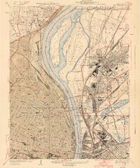 1940 Granite City1940 Print · USGSThe industrial heart of the bi-state region comes alive in this 1940s survey of the riverfront between Illinois and Missouri. Researchers can trace the massive rail yards and river docks supporting Granite City, alongside historic landmarks like Union Station, St Louis University, and the Bellefontaine Cemetery.4 unique versions available
 - 1940 Map of Cahokia
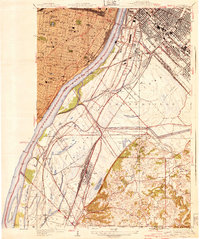 1940 Cahokia1940 Print · USGSThe industrial riverfront south of St Louis thrived in the early twentieth century as a massive rail and shipping hub. Trace the development of Cahokia and Dupo or locate landmarks like the U S Marine Hospital and the Lark Cem.3 unique versions available
Showing maps 1-25 of 201
Top cities of Saint Clair County
- Belleville historical maps
- O'Fallon historical maps
- East St. Louis historical maps
- Fairview Heights historical maps
- Swansea historical maps
- Shiloh historical maps
See more
Frequently asked questions
- What are the different types of historical maps available for Saint Clair County?
- What is the oldest map of Saint Clair County?
- Where can I purchase historical maps of Saint Clair County for my home or office?
- Where can I download high-res historical maps of Saint Clair County?
- Are there historical topographic maps available for Saint Clair County?
- Is there historical aerial imagery available for Saint Clair County?
- Where are historical maps of Saint Clair County sourced from?