1970s Maps of Saint Clair County, Illinois
Explore 2 historic maps of Saint Clair County from the 1970s. These maps offer a rare glimpse into what life looked like during the 1970s — showing old roads, neighborhoods, homes, and landmarks that have changed or disappeared over time.
Whether you're researching your family's past, planning a metal detecting trip, or studying how Saint Clair County's landscape evolved across the 1970s, these high-resolution maps are a powerful tool for exploring the history of this region.
- Focus on a specific era: All maps on this page are from the 1970s, giving you a focused view of this time period.
- See what’s changed: Compare century-old streets, trails, and buildings to today's modern landscape using overlays and satellite layers.
- Research with precision: Use these maps for genealogy, historical research, land use analysis, or educational projects.
- View, download, or print: Maps are fully viewable online in high resolution, and can be downloaded or printed for your own records.
Start exploring Saint Clair County's history through authentic maps from the 1970s. This is your window into the past.
Saint Clair County, IL maps
(2)- 1970 Map of Baldwin, 1972 Print
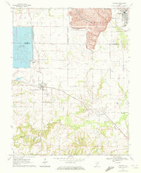 1970 Baldwin1972 Print · USGSThe border of Randolph and St. Clair counties at the start of the 1970s shows a region balanced between coal mining and small-town life. Researchers can trace rural lineages through numerous sites like St Johns Cem, Lessley Cem, and the St Johns Sch.2 unique versions available
 - 1970 Map of Red Bud, 1972 Print
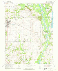 1970 Red Bud1972 Print · USGSRed Bud and the surrounding Horse Prairie are captured here at the start of the 1970s during a period of significant river engineering. Researchers can trace family sites like Brickley Cemetery or follow the Gulf Mobile and Ohio rail line past Trinity School.3 unique versions available
End of results
Showing maps 1-2 of 2
Top cities of Saint Clair County
- Belleville historical maps
- O'Fallon historical maps
- East St. Louis historical maps
- Fairview Heights historical maps
- Swansea historical maps
- Shiloh historical maps
See more
Frequently asked questions
- What are the different types of historical maps available for Saint Clair County?
- What is the oldest map of Saint Clair County?
- Where can I purchase historical maps of Saint Clair County for my home or office?
- Where can I download high-res historical maps of Saint Clair County?
- Are there historical topographic maps available for Saint Clair County?
- Is there historical aerial imagery available for Saint Clair County?
- Where are historical maps of Saint Clair County sourced from?