1990s Maps of Mascoutah, Illinois
Explore 2 historic maps of Mascoutah from the 1990s. These maps offer a rare glimpse into what life looked like during the 1990s — showing old roads, neighborhoods, homes, and landmarks that have changed or disappeared over time.
Whether you're researching your family's past, planning a metal detecting trip, or studying how Mascoutah's landscape evolved across the 1990s, these high-resolution maps are a powerful tool for exploring the history of this region.
- Focus on a specific era: All maps on this page are from the 1990s, giving you a focused view of this time period.
- See what’s changed: Compare century-old streets, trails, and buildings to today's modern landscape using overlays and satellite layers.
- Research with precision: Use these maps for genealogy, historical research, land use analysis, or educational projects.
- View, download, or print: Maps are fully viewable online in high resolution, and can be downloaded or printed for your own records.
Start exploring Mascoutah's history through authentic maps from the 1990s. This is your window into the past.
Mascoutah, IL maps
(2)- 1990 Map of Mascoutah, 1991 Print
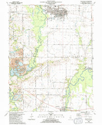 1990 Mascoutah1991 Print · USGSSt. Clair County at the start of the nineties reveals a landscape of established coal mining and deep-rooted family farms. Genealogists can locate numerous small burial plots like John Mueller Cem and trace the industrial footprint of the River King Mine No 1.
 - 1991 Map of Lebanon
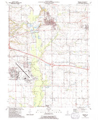 1991 Lebanon1991 Print · USGSSt. Clair County in the early nineties features a mix of military aviation and historic college town life. Genealogists can trace family sites at Summerfield Cem and Middlecoff Cem, or locate landmarks like McKendree College and Scott Air Force Base.
End of results
Showing maps 1-2 of 2
Top cities near Mascoutah
- Belleville historical maps
- O'Fallon historical maps
- Collinsville historical maps
- Fairview Heights historical maps
- Swansea historical maps
- Shiloh historical maps
See more
Frequently asked questions
- What are the different types of historical maps available for Mascoutah?
- What is the oldest map of Mascoutah?
- Where can I purchase historical maps of Mascoutah for my home or office?
- Where can I download high-res historical maps of Mascoutah?
- Are there historical topographic maps available for Mascoutah?
- Is there historical aerial imagery available for Mascoutah?
- Where are historical maps of Mascoutah sourced from?