1960s Maps of Sangamon County, Illinois
Explore 9 historic maps of Sangamon County from the 1960s. These maps offer a rare glimpse into what life looked like during the 1960s — showing old roads, neighborhoods, homes, and landmarks that have changed or disappeared over time.
Whether you're researching your family's past, planning a metal detecting trip, or studying how Sangamon County's landscape evolved across the 1960s, these high-resolution maps are a powerful tool for exploring the history of this region.
- Focus on a specific era: All maps on this page are from the 1960s, giving you a focused view of this time period.
- See what’s changed: Compare century-old streets, trails, and buildings to today's modern landscape using overlays and satellite layers.
- Research with precision: Use these maps for genealogy, historical research, land use analysis, or educational projects.
- View, download, or print: Maps are fully viewable online in high resolution, and can be downloaded or printed for your own records.
Start exploring Sangamon County's history through authentic maps from the 1960s. This is your window into the past.
Sangamon County, IL maps
(9)- 1961 Map of New City
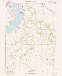 1961 New City1961 Print · USGSSangamon County at the start of the 1960s reveals a landscape balancing suburban growth near Southlawn with the rural traditions of Cotton Hill. Researchers can locate historic family sites like Brunk Cem, the village of New City, and the Baltimore and Ohio rail line.3 unique versions available
 - 1961 Map of Decatur
 1961 Decatur1961 Print · USGSCentral Illinois in the late fifties was a bustling corridor of rail lines and prairie commerce centered on the state capital. Genealogists and historians can trace the intricate connections between Springfield, Decatur, and dozens of smaller settlements like Nokomis and Arcola.2 unique versions available
 - 1961 Map of Chatham, 1962 Print
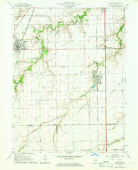
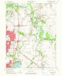
 1961 Chatham1962 Print · USGSIn the early sixties, the area south of Springfield was a network of emerging suburbs and vital rail corridors centered around Chatham. Genealogists and historians can trace family landmarks like Stout Cem, local education at Glenwood Sch, and a rare Covered Bridge over Sugar Creek.3 unique versions available
 - 1964 Map of Pawnee, 1966 Print
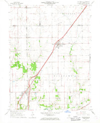
 1964 Pawnee1966 Print · USGSPawnee and the surrounding Illinois prairie are captured here in the mid-1960s, showing a landscape defined by the Chicago and Illinois Midland rail line. Researchers can trace the industrial footprint of the Claypit and Mine, or locate rural landmarks like Zenobia Ch and Horse Creek Cem.4 unique versions available
 - 1965 Map of Divernon, 1966 Print
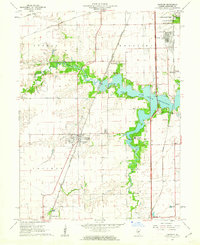
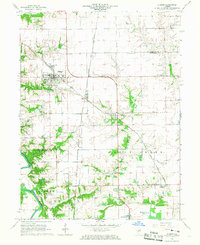
 1965 Divernon1966 Print · USGSCentral Illinois prairie life and rail transport thrive in this mid-sixties survey of Sangamon County. Genealogists and historians can trace family ties at Wimmer Cem or locate the rural junctions of Cimic and Pawnee Junction along the rail lines.3 unique versions available
 - 1965 Map of Springfield West, 1966 Print
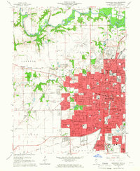 1965 Springfield West1966 Print · USGSMid-century Springfield is shown here as a bustling state capital and rail center during a period of significant suburban expansion. Researchers can pinpoint Lincolns Tomb, trace the many rail lines like the Illinois Terminal, and find dozens of local landmarks from the Illini Country Club to Oak Ridge Cemetery.3 unique versions available
 - 1965 Map of Springfield East, 1966 Print
 1965 Springfield East1966 Print · USGSThe eastern edges of Springfield and the Sangamon River valley are captured here in the mid-1960s during a period of infrastructure growth. Genealogists and local historians can trace family locations at Camp Butler Cem, find the rural Bissell Cem, or locate the historic St Johns Sanitarium.4 unique versions available
 - 1966 Map of Athens, 1967 Print
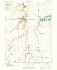
 1966 Athens1967 Print · USGSNorth of Springfield in the mid-1960s, this area shows the rail junctions of Athens and Cantrall during a period of steady rural growth. Researchers can trace family history at Brittin Cem or locate the former Barr Station and the Sangamon River oxbows.3 unique versions available
 - 1966 Map of Williamsville, 1967 Print
 1966 Williamsville1967 Print · USGSCentral Illinois farmland in the mid-sixties shows a landscape defined by rail corridors and creek bottoms. Trace family sites near Williamsville and Sherman, including several old burial grounds like Wolf Creek Cem and Stewart Cem.3 unique versions available
End of results
Showing maps 1-9 of 9
Top cities of Sangamon County
- Springfield historical maps
- Woodside historical maps
- Chatham historical maps
- Auburn historical maps
- Sherman historical maps
- Riverton historical maps
See more
Frequently asked questions
- What are the different types of historical maps available for Sangamon County?
- What is the oldest map of Sangamon County?
- Where can I purchase historical maps of Sangamon County for my home or office?
- Where can I download high-res historical maps of Sangamon County?
- Are there historical topographic maps available for Sangamon County?
- Is there historical aerial imagery available for Sangamon County?
- Where are historical maps of Sangamon County sourced from?