1970s Maps of Pasfield, Illinois
Explore 2 historic maps of Pasfield from the 1970s. These maps offer a rare glimpse into what life looked like during the 1970s — showing old roads, neighborhoods, homes, and landmarks that have changed or disappeared over time.
Whether you're researching your family's past, planning a metal detecting trip, or studying how Pasfield's landscape evolved across the 1970s, these high-resolution maps are a powerful tool for exploring the history of this region.
- Focus on a specific era: All maps on this page are from the 1970s, giving you a focused view of this time period.
- See what’s changed: Compare century-old streets, trails, and buildings to today's modern landscape using overlays and satellite layers.
- Research with precision: Use these maps for genealogy, historical research, land use analysis, or educational projects.
- View, download, or print: Maps are fully viewable online in high resolution, and can be downloaded or printed for your own records.
Start exploring Pasfield's history through authentic maps from the 1970s. This is your window into the past.
Pasfield, IL maps
(2)- 1971 Map of Farmingdale, 1973 Print
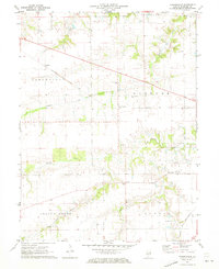 1971 Farmingdale1973 Print · USGSSangamon County remains a vital rail and farming corridor in the early seventies, centered on the village of Farmingdale. Researchers can locate historic landmarks like the Covered Bridge, New Salem Ch, and the Farmingdale Sch.
 - 1976 Map of Farmingdale, 1978 Print
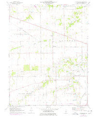 1976 Farmingdale1978 Print · USGSSangamon County farmland in the mid-1970s is shown in transition as rail corridors like the Baltimore and Ohio cross the prairie. Researchers can trace family history through sites like Farmingdale Cem, Riddle Hill, and the Farmingdale Sch.
End of results
Showing maps 1-2 of 2
Top cities near Pasfield
- Springfield historical maps
- Woodside historical maps
- Chatham historical maps
- Auburn historical maps
- Sherman historical maps
- Pawnee historical maps
See more
Frequently asked questions
- What are the different types of historical maps available for Pasfield?
- What is the oldest map of Pasfield?
- Where can I purchase historical maps of Pasfield for my home or office?
- Where can I download high-res historical maps of Pasfield?
- Are there historical topographic maps available for Pasfield?
- Is there historical aerial imagery available for Pasfield?
- Where are historical maps of Pasfield sourced from?