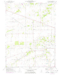
1976 Map of Farmingdale
USGS Topo · Published 1978About this map
Gently rolling Sangamon County farmland is defined by the east-west corridor of the Baltimore and Ohio railroad, which links the rural settlements of Richland and Farmingdale. The landscape is a network of drainage basins, with Prairie Creek and Spring Creek carving shallow valleys through the agricultural grid. This 1970s record captures the region's enduring rural character, centered around localized community hubs like the Farmingdale Sch and the New Salem Ch.
Find a feature on this map
25 named features on this map. Tap any name to fly to it.
Don’t see what you’re looking for? This feature index may not catch every label — zoom into the map to look around manually.
Map Details
Editions of this 1976 Farmingdale Map
This is the sole edition of this map. No revisions or reprints were ever made.
Other maps of this area

1907 · Springfield
USGS Topo · 1:62,500

1909 · Tallula
USGS Topo · 1:62,500

1922 · Divernon
USGS Topo · 1:62,500

1924 · Divernon
USGS Topo · 1:62,500

1924 · Waverly
USGS Topo · 1:62,500

1926 · Waverly
USGS Topo · 1:62,500

1930 · Springfield
USGS Topo · 1:62,500

1940 · Tallula
USGS Topo · 1:62,500

1940 · Springfield
USGS Topo · 1:62,500

1950 · Springfield West
USGS Topo · 1:24,000