1980s Maps of Findlay, Illinois
Explore 3 historic maps of Findlay from the 1980s. These maps offer a rare glimpse into what life looked like during the 1980s — showing old roads, neighborhoods, homes, and landmarks that have changed or disappeared over time.
Whether you're researching your family's past, planning a metal detecting trip, or studying how Findlay's landscape evolved across the 1980s, these high-resolution maps are a powerful tool for exploring the history of this region.
- Focus on a specific era: All maps on this page are from the 1980s, giving you a focused view of this time period.
- See what’s changed: Compare century-old streets, trails, and buildings to today's modern landscape using overlays and satellite layers.
- Research with precision: Use these maps for genealogy, historical research, land use analysis, or educational projects.
- View, download, or print: Maps are fully viewable online in high resolution, and can be downloaded or printed for your own records.
Start exploring Findlay's history through authentic maps from the 1980s. This is your window into the past.
Findlay, IL maps
(3)- 1983 Map of Kirksville
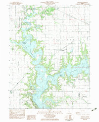 1983 Kirksville1983 Print · USGSThe Lake Shelbyville area is shown here in the early eighties as the reservoir reshaped the Moultrie and Shelby county lines. Genealogists and local historians can trace rural roots through landmarks like Henderson Cem, Oak Grove Ch, and the village of Kirksville.
 - 1983 Map of Findlay
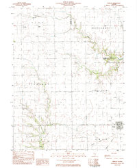 1983 Findlay1983 Print · USGSShelby County in the early eighties shows a landscape of steady agricultural life centered on Findlay. Genealogists and local historians can trace family locations near Prairie Home Cem, St Marys Ch, or along the Missouri Pacific rail corridor.
 - 1985 Map of Decatur
 1985 Decatur1985 Print · USGSCentral Illinois farming and rail hubs thrive in the mid-1980s as Decatur anchors a sprawling network of track and timber. Trace the paths of the Sangamon River and the Illinois Central Gulf RR through old towns like Cerro Gordo and Bement.2 unique versions available
End of results
Showing maps 1-3 of 3
Top cities near Findlay
- Shelbyville historical maps
- Sullivan historical maps
- Bethany historical maps
- Lovington historical maps
- Windsor historical maps
- Tower Hill historical maps
See more
Frequently asked questions
- What are the different types of historical maps available for Findlay?
- What is the oldest map of Findlay?
- Where can I purchase historical maps of Findlay for my home or office?
- Where can I download high-res historical maps of Findlay?
- Are there historical topographic maps available for Findlay?
- Is there historical aerial imagery available for Findlay?
- Where are historical maps of Findlay sourced from?