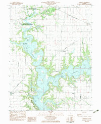
1983 Map of Kirksville
USGS Topo · Published 1983About this map
Lake Shelbyville dominates this Central Illinois landscape, having transformed the valleys of the Kaskaskia River and Okaw River into a sprawling reservoir. The map reveals the intricate shoreline where the water meets the West Okaw River State Fish and Wildlife Management Area, preserving a significant portion of the river corridor. Settlement patterns here are defined by the transition from river-bottom agriculture to recreation and conservation, with several cemeteries such as Thomason Cem and Hampton Cem remaining as quiet landmarks of the earlier rural community.
Find a feature on this map
33 named features on this map. Tap any name to fly to it.
Don’t see what you’re looking for? This feature index may not catch every label — zoom into the map to look around manually.
Map Details
Editions of this 1983 Kirksville Map
This is the sole edition of this map. No revisions or reprints were ever made.
Other maps of this area

1935 · Sullivan
USGS Topo · 1:48,000

1940 · Sullivan
USGS Topo · 1:62,500

1942 · Shelbyville
USGS Topo · 1:62,500

1946 · Shelbyville
USGS Topo · 1:62,500

1947 · Stewardson
USGS Topo · 1:62,500

1949 · Stewardson
USGS Topo · 1:62,500

1949 · Dalton City
USGS Topo · 1:62,500

1958 · Decatur
USGS Topo · 1:250,000

1961 · Decatur
USGS Topo · 1:250,000

1980 · Middlesworth
USGS Topo · 1:24,000