
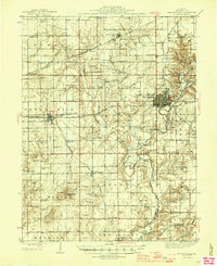
1946 Map of Shelbyville
USGS Topo · Published 1946About this map
The Kaskaskia River snakes through the eastern half of this landscape, its path marked by crossings like Shellenbarker Bridge and the Copeland Bridge. As the county seat, Shelbyville serves as the central hub, surrounded by a dense network of township-level settlements and rural institutions from the mid-1940s. The map reveals an agrarian society deeply rooted in local districts, evidenced by the numerous small schools such as Ragweed Sch, Little Brick Sch, and Rose Center Sch.
Find a feature on this map
104 named features on this map. Tap any name to fly to it.
Don’t see what you’re looking for? This feature index may not catch every label — zoom into the map to look around manually.
Map Details
Editions of this 1946 Shelbyville Map
2 editions found
Other maps of this area

1935 · Sullivan
USGS Topo · 1:48,000

1940 · Sullivan
USGS Topo · 1:62,500

1941 · St. Elmo
USGS Topo · 1:62,500

1942 · Shelbyville
USGS Topo · 1:62,500

1944 · Ramsey
USGS Topo · 1:62,500

1945 · St. Elmo
USGS Topo · 1:62,500

1946 · Ramsey
USGS Topo · 1:62,500

1947 · Pana
USGS Topo · 1:62,500

1947 · Stewardson
USGS Topo · 1:62,500

1949 · Stewardson
USGS Topo · 1:62,500