
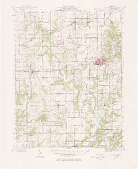
1942 Map of Shelbyville
USGS Topo · Published 1958About this map
The Kaskaskia River carves a winding path through the center of Shelby County, anchoring a landscape of small townships and riverside crossings. In the early 1940s, the county seat of Shelbyville served as the primary hub, where the New York Central and Chicago and Eastern Illinois railroads converged. The terrain rises to its highest point at Williamsburg Hill, while the surrounding countryside is marked by a dense network of one-room schools like Sandy Hill School and Ragweed School, reflecting the rural educational structure of the mid-century era. River travel and local transport relied on several named spans, including Shellenbarger Bridge and Thompson Mill Bridge. Genealogists will find a wealth of burial sites, from the prominent Glenwood Cem to the smaller Gallagher Chapel Cem, documenting the area's long-established family roots.
Find a feature on this map
143 named features on this map. Tap any name to fly to it.
Don’t see what you’re looking for? This feature index may not catch every label — zoom into the map to look around manually.
Map Details
Editions of this 1942 Shelbyville Map
2 editions found
Other maps of this area

1935 · Sullivan
USGS Topo · 1:48,000

1940 · Sullivan
USGS Topo · 1:62,500

1941 · St. Elmo
USGS Topo · 1:62,500

1944 · Ramsey
USGS Topo · 1:62,500

1945 · St. Elmo
USGS Topo · 1:62,500

1946 · Shelbyville
USGS Topo · 1:62,500

1946 · Ramsey
USGS Topo · 1:62,500

1947 · Pana
USGS Topo · 1:62,500

1947 · Stewardson
USGS Topo · 1:62,500

1949 · Stewardson
USGS Topo · 1:62,500