1940s Maps of Stark County, Illinois
Explore 4 historic maps of Stark County from the 1940s. These maps offer a rare glimpse into what life looked like during the 1940s — showing old roads, neighborhoods, homes, and landmarks that have changed or disappeared over time.
Whether you're researching your family's past, planning a metal detecting trip, or studying how Stark County's landscape evolved across the 1940s, these high-resolution maps are a powerful tool for exploring the history of this region.
- Focus on a specific era: All maps on this page are from the 1940s, giving you a focused view of this time period.
- See what’s changed: Compare century-old streets, trails, and buildings to today's modern landscape using overlays and satellite layers.
- Research with precision: Use these maps for genealogy, historical research, land use analysis, or educational projects.
- View, download, or print: Maps are fully viewable online in high resolution, and can be downloaded or printed for your own records.
Start exploring Stark County's history through authentic maps from the 1940s. This is your window into the past.
Stark County, IL maps
(4)- 1944 Map of Kewanee
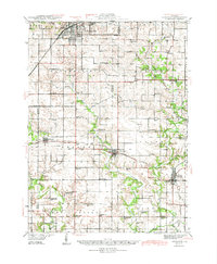 1944 Kewanee1944 Print · USGSHenry and Stark Counties in the 1940s show a landscape of thriving rail towns and closely spaced country schoolhouses. Genealogists can locate family-named landmarks like Cavanagh Cem and Bumble Bee Sch along the Spoon River valley.3 unique versions available
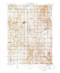
 - 1944 Map of Elmwood, 1967 Print
 1944 Elmwood1967 Print · USGSPeoria and Stark counties during the mid-forties reveal a landscape of thriving rail hubs and tightly knit rural school districts. Researchers can trace the legacy of local education and faith at Paradise Chapel Sch, Jubilee College State Park, and the Southport Cem.2 unique versions available
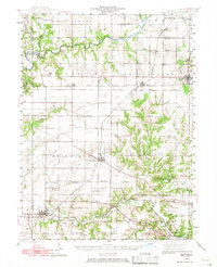
 - 1945 Map of Bradford
 1945 Bradford1945 Print · USGSSettlement and agriculture in Stark and Bureau Counties reached a peak of rural infrastructure in the mid-1940s. Genealogists can trace family footprints across dozens of country school sites like Osceola Center Sch and churches such as Willow Springs Ch.3 unique versions available
 - 1948 Map of Elmwood
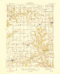 1948 Elmwood1948 Print · USGSPeoria and Stark counties were bustling agricultural and rail hubs in the late 1940s. Genealogists and historians can trace dozens of country schools and churches, including Paradise Chapel, Dixie Sch, and Southport Cem near the Spoon River.2 unique versions available
End of results
Showing maps 1-4 of 4
Top cities of Stark County
- Wyoming historical maps
- Toulon historical maps
- Osceola historical maps
- Bradford historical maps
- Elmira historical maps
- West Jersey historical maps
Frequently asked questions
- What are the different types of historical maps available for Stark County?
- What is the oldest map of Stark County?
- Where can I purchase historical maps of Stark County for my home or office?
- Where can I download high-res historical maps of Stark County?
- Are there historical topographic maps available for Stark County?
- Is there historical aerial imagery available for Stark County?
- Where are historical maps of Stark County sourced from?